


Attribute Update
Function Description
According to the spatial relationship, update the dataset object attributes.
The Attribute Update function provides two options to update the Target Dataset. The first option is to update the entire Dataset. The second option is to update by pressing Filter Expression.
Function entrance
- Data tab-> Data Processing-> Vector-> Attribute Update, the Attribute Update dialog pops up.
- Toolbox-> Data Processing-> Vector-> Attribute Update, the Attribute Update dialog pops up.
Parameter description
- Data with attirbutes offered: Select the Data with attirbutes offset source and Dataset. If Dataset is selected in Workspace Manager, the Dataset is the default Data with attirbutes offered.
- Target Dataset: Set the New Dataset to be updated and its Datasource.
- Statistic Field: Select a field to store the number of updated sub-objects. Unupdated subobjects are assigned a value of 0, and updated subobjects are counted in the order of 1, 2, 3.
- Filter Expression: Click the button on the right to Set fields Filter in the SQL Expression dialog box that pops up , and filter the objects that meet the expression conditions in the Target Dataset when updating the attributes. Select Fields in the Source Dataset are not updated into these Object Properties.
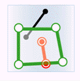
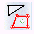
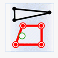
- Spatial Relationship: Spatial relationship refers to the spatial relationship between the provided attribute Geometry and the target Geometry. There are three relationships: Contain, Contained and Intersect. The spatial relationship is described as follows: In
the following figure, green represents the objects in the Provide Attribute Data set, red represents the Target satisfying the spatial relationship, and black represents the Target not satisfying the spatial relationship.
- Contains: Geometry in Provide Attribute Data contains Geometry in Target Dataset.
Object Target point Target line Target surface Provide Attribute Points 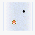
Provide attribute line 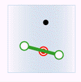
Provide Attribute Faces 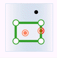
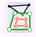
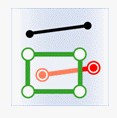
- Included: Geometry in Provide Attribute Data is included by Geometry in Target Dataset.
Object Target point Target line Target surface Provide Attribute Points 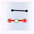
Provide attribute line 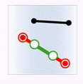
Provide Attribute Faces 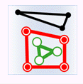
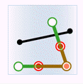
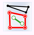
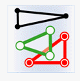
- Intersect: Geometry in Provide Attribute Data set is intersected with Geometry in Target Dataset.
Object Target point Target line Target surface Provide Attribute Points 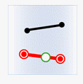
Provide attribute line 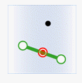
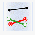
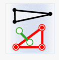
Provide Attribute Faces 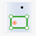
- Contains: Geometry in Provide Attribute Data contains Geometry in Target Dataset.
- Boundary Processing: Used to determine whether the spatial relationship attributes the boundary of the face object to the inside of the face. It can be set to Not Contain Border and Contain Border. This combo box is activated only when you need to determine the inclusion relationship between a face and a point or the intersection relationship between a face and a line.
- Contain Border: indicates that the point on the face boundary belongs to the point contained by the face. When the point on the line coincides with the point on the face boundary, it indicates that the face intersects with the line.
- Not Contain Border: indicates that the point on the boundary of the face is not included in the face, and the point on the line is only coincident with the point on the boundary of the face but not in the face. In this case, the intersection is not counted.
- Value-taking method: if there are multiple objects that meet the conditions and can Provide Attribute Data, the provided attribute object will be assigned to Target after being processed by a certain value-taking method.
- Assign Value: Randomly select one of the attribute data for update. This method is suitable for one-to-one assignment.
- Average: Take the average value for update. Valid for fields of numeric type.
- Sum: Take the sum of the attributes of each object for update. Valid for fields of numeric type.
- Maximum value: The maximum value in each Object Properties is used for updating. Valid for fields of numeric type.
- Minimum value: The minimum value among the Object Properties is used for updating. Valid for fields of numeric type.
- Max SMID: Take the Object Properties value with the largest SmID for update.
- Min SMID: The Object Properties value with the smallest SmID is taken for the update.
- Maximum Intersection Area: If there are multiple intersecting sub-objects in the space, the Object Properties value with the largest intersection area is used for the update.
- Field Settings: In the list, check Provide Attribute Fields for Data Update, select the corresponding Target Field, and click again. You can select the settings (select the Target Field to update to).
 Caution:
 Support cross-type storage of update results to reduce users' secondary processing of update results, and support Attribute Update for new Target Fields.
- After the update is completed, the fields in the Target Dataset property table (new or existing fields) will update the corresponding field values in the Source Dataset.
Caution: - When
- setting fields, the source field must be the same as the target Type. Different Types cannot be assigned.
- Different statistical methods need to correspond to different Statistic Fields. Assign Value, Max SMID, and Min SMID are numeric or Text. Boolean, Memo, and Date types are not supported. Average, Sum, Maximum, and Minimum are numeric fields.
Related topics