


Thiessen Polygon Application Example
This example is based on the national weather station data, for its Construct Thiessen Polygon, the attributes of the point data are reflected to the area object of the area object, and the average rainfall of each weather station construction area is obtained, and the Graudated Colors Map is made to analyze the rainfall of each area.
The specific operation steps are as follows:
- In the Current Workspace, open the China. Udbx in the Sample Data and create a new File Database named Thiessen.
- The observed data of national meteorological stations are Excel data, which are imported into Thiessen Datasource, and the imported Tabular Dataset is used to Convert to Point data through the data Type Conversion function.
- Create a new Map, add the Province _ RDataset to the new Map, enable the layer editing function, select all the face objects in the layer, and combine all the face objects into one face object through the Combination function in the Object Operation "tab.
- Click the Proximity Analysis "Drop-down Button in the Vector Analysis" group in the Spatial Analysis "tab, and select the Thiessen Polygon" item. In the Construct Thiessen Polygon "dialog box that opens,
- Set the Source Dataset to the Weather Site data in the dialog box.
- Make a Graudated Colors Map for the constructed Thiessen Polygon data, set the expression in the Thematic Map Properties Panel as the "Annual Precipitation" field, set the number of segments as 15, and reset the segment values. Finally, the national Rainfall Distribution Map can be obtained as shown in the following figure:
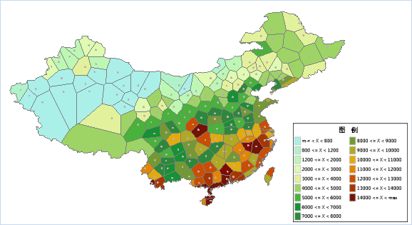 |
| Figure: National Rainfall Distribution Map. |
 Related topics
 Thiessen Polygon Construction Principles