Query grid values
Instructions for use
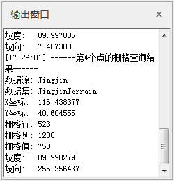
Query the grid value at the position of the mouse. The default Search Result displays the Datasource, Dataset, X coordinate, Y coordinate, grid row, grid column, grid value, slope, and aspect values for the grid cell. Raster Query for Mosaic Dataset is supported.
Function entrance
- On the Spatial Analysis tab-> Raster Analysis-> Raster Query;
Operating instructions
- In the process of moving the mouse, an instant message box appears at the tail of the mouse, and the grid value information of the position where the mouse is located is displayed in real time, including the Datasource and Dataset where the Raster Data is located. The GCS (X and Y coordinates), Grid Coordinates (row and column numbers), grid values, and slope and aspect values for the grid location, as shown in the following illustration.
- Click the Drop-down Button of the Raster Query "function to pop up the Raster Query Settings dialog box. You can set whether to Display Raster Information, Display Slope and Aspect and other information when querying.
- Display Raster Information: Check this check box to indicate that the Search Result will display the grid row, grid column and grid value information of the cell where the mouse is located; Unchecking the check box means that there is no Display Raster Information in the Search Result.
- Display Slope and Aspect: Select this check box to indicate that the Search Result will display the Slope Aspect value of the cell where the mouse is located; Unchecking the check box means that there is no Display Slope and Aspect in the Search Result.
- Elevation Scaling Factor: When the unit of the terrain grid value (i.e. elevation value) is different from the unit of the X and y coordinates, it is usually necessary to multiply the elevation value by an elevation scaling factor to make the three units consistent. For example, the units in the X and Y directions are meters, and the units in the Z direction are feet. Since 1 foot equals 0.3048 meters, you need to specify a scaling factor of 0.3048. If set to 1, there is no scaling. The Projected Coordinate System (in meters) is the
recommended data for analysis. If you choose to run the analysis in a spherical coordinate system, you need to specify an appropriate z-factor for the latitude. If the X, y units are latitude and longitude and the Z unit is the meter, some appropriate Z factors listed in the following table may be used:
Latitude Z-factor 0 0.00000898 10 0.00000912 20 0.00000956 30 0.00001036 40 0.00001171 50 0.00001395 60 0.00001792 70 0.00002619 80 0.00005156
- Click the grid value you want to query with the mouse, a point will be highlighted on the Map, and the GCS, Grid Coordinates and grid value of the point will be displayed in the Output Window. If multiple grid points are queried at the same time, these points will be numbered automatically to facilitate the user to distinguish.
- Hold down the ESC key or right-click to cancel the query, and hold down the ESC key to simultaneously clear the grid points highlighted by Map.
 |
| Query grid values |
 |
| Output Window information |


 Related topics