This text sums up the factors that mainly affect the display performances and display effects of the map in the application programs, and provides corresponding optimization strategies. Of course, usually the display performances and display effects of the same map cannot be simultaneously satisfied, and users can make their choices flexibly according to the specific situations.
1. Optimizing the Display Effects of the Map
2. Optimizing the Display Speed of the Map
1. Optimizing the Display Effects of the Map
The methods of optimizing the display effects of the map include: map antialiasing, changing the layer order, optimizing text overlap, etc.
 Enabling Map Antialiasing
Antialiasing: When drawing a non-horizontal and non-vertical line border or polygon border on the raster display device, the jagged or stepped appearances will be presented more or less. This is because that the line, polygon, or color border is continuous, whereas the raster consists of discrete points. When representing a line or a polygon on the raster display device, it must sample at discrete locations. The information aliasing after reconstruction caused by inadequate sampling is called "aliasing". The technology used to reduce or eliminate this effect is called antialiasing.
Map Antialiasing: The antialiasing process implemented for the lines, polygons, texts in the map, aiming at the map information aliasing, which includes line antialiasing and text antialiasing.
About how to set map antialiasing effects, please refer to Enabling Line Antialiasing and Enabling Text Antialiasing.
Changing the Layer Order
In a map, the overlap order of each layer will directly affect the display effects of the map. Changing the layer order of the map is a most fundamental and simplest method of optimizing map display effects.
About how to change layer order, please refer to Changing the Layer Order.
Optimizing Text Overlap
In the map display, the overlap may appear among multiple texts, which will affect the map display effects. There are two kinds of best solutions:
- Filtering out a part of overlapping texts through filtering display, and retaining an entire text object according to the existing priority of the overlapping texts or specific requirements.
- Within a suitable range, in the situation that the texts are simultaneously displayed, solving the overlap by automatic avoiding among the texts.
The application programs provide the functions of filtering display and automatic avoiding for overlapping texts, in order to solve the text overlap.
Filtering out Overlapping Text
For the text layer, the input text object can be filtered out automatically by setting not to display the overlapping text object, so as to avoid the overlap. For more details, please refer to Filtering out Overlapping Text in a Map.
Avoiding Text Overlap Automatically
For the label map, the labels can be displayed simultaneously without interactions in a suitable range, by setting the automatic avoiding of texts. For more details, please refer to Properties in the label map.
Overlay Settings
When there are many layers on the map, the overlay objects may be appeared. For example, the point layer overlays with the ThemeLabel layer and so on. See Overlay Settings for more information.
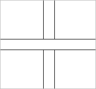
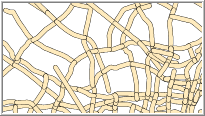
Optimizing Cross Lines
On the map, cross lines, such as pipeline, rivers, will occur. It may cause incorrect connectivity.
So, we need to optimized those cross lines.
 |
 |
| Cross lines without optimizing | Cross lines optimized |
SuperMap Desktop provides this function. See Start Cross Optimization.
 |
 |
| Cross lines without optimizing | Cross lines optimized |
2. Optimizing the Display Speed of the Map
In the application programs, optimizing the display speed of the map is mainly realized by reducing the displayed layers and objects in the map, so as to improve the display and browse speed. The method of optimizing the display speed of the map include: filtering objects, filtering layers, map caches, etc.
Filtering Scene Objects
During the map display, it often needs to filter some objects according to certain conditions in order to improve the browse speed.
Filtering Map Objects
The application programs provide the function of filtering display conditions to filter and display objects in the layer. By setting the filtering expression, only the geometry objects that satisfy the conditions are displayed in the map layer. For more details, please refer to Filtering Map Objects.
Setting the Minimum Visible Size
In the map, some objects that are too small need to be filtered out, so as to avoid the influence on the display speed. For example, filter the line objects with the screen lengths less than or equal to 20mm in a line layer, so that they are not displayed in the layer.
The application programs provide the function of setting the minimum size of displayed objects, which can filter out the geometry objects (except for the point objects) that the screen lengths of the longer sides of the enclosing rectangles are less than or equal to the specified length in the map layer. For more details, please refer to Setting the Minimum Visible Size.
Setting the Visible Text Size Range
The application programs provide the function of filtering display conditions to filter and display the font height of the text in the layer. By setting the filtering expression, only the text objects within the font height range are displayed in the map. For more details, please refer to Setting the Visible Text Size Range.
Filtering Layers
The application programs provide the function of filtering layers, which mainly refers to filtering the layer scale, including: setting the visible scale and using the fixed scale for the layer.
Enabling the Visible Property
In the application programs, you can control whether to display a layer by the Visible property.
In some maps there may exist tens or hundreds of layers, some of which may not need to be displayed (for example, a thematic map has been made for a vector layer, and the thematic map layer has been displayed, then the original layer may not be displayed), then these layers can be filtered out by canceling the Visible property of the layer. For more details, please refer to Enabling the Visible Property.
Setting the Visible Scale Range
In the map display, the layer often needs to be filtered according to different scales, for example:
- In the current map, the A layer will not be displayed if it is smaller than the current scale, or if it is larger than the current scale;
- In the current map, the A layer will be displayed when the scale is 1:10000, and it will not be displayed when the scale is 1:50000.
You are allowed to control the visibility of layers at different scales. For more details, please refer to Setting the Visible Scale Range.
Using Fixed Scales
When the cartographic data size is relatively large, the speed of zooming in and zooming out the map may be affected. The map display speed can be improved by setting a series of fixed scales for the map.
Set a series of scales, then the system will zoom in/out the map according to the specified scales when the map is zoomed in/out. For example, set four fixed scales 1:10000, 1:25000, 1:50000, 1:100000. If the current scale of the map is 1:30000, then the scale will become 1:25000 after the map is zoomed in, and the scale will become 1:10000 after the map is zoomed in again, then the Zoom In operation will not be implemented for the map; then if the map is zoomed out, the scale will become 1:25000, then become 1:50000, 1:100000, and then the Zoom Out operation will also not be implemented for the map.
Map Cache
The function of map caches is to create a series of cache pictures for the map according to the specified scales and cache ranges. You can directly read the pictures in the caches when browsing the map, so as to improve the display speed of the map. About how to create and add map caches, please refer to Creating 2D Map Caches and Adding Caches.