 Introduction
Create 3D caches for image data to optimize the display and browsing effects.
Basic Steps
- Select "Create Scene Cache ..." in the dataset context menu.
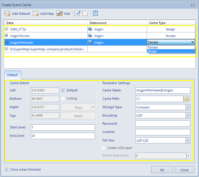
- The Create Scene Cache dialog box shows up. Image datasets can be added through the Add Dataset button. SIT files can be added through the Add File button.
- Click
 to display the select dialog box. All datasources in the current workspace are listed in the left pane. In the right pane is the datasets in the datasource highlighted in the left pane. Filter, find and select datasets with commands provided on the toolbar.
 - Click
 to add the SIT image file to be cached.
 - Click Open to go back to the Create Scene Cache dialog box and the selected image datasets and SIT files are added to the list for cache creation.
- The data list:
- Data: The dataset to create image cache.
- Datasource: The datasource where the data is located. The Datasource for data items added through the Add Files button is displayed as empty.
- Cache Type: The type of the 3D cache. When creating 3D caches for image datasets, the Cache Type is displayed as Image. All supported cache types for the data item is listed in the Cache Type drop-down list for you to choose. For DEM data, you can create both terrain caches and image caches fot it. Here we select Image from the dropdown list.
- Tile Type: There are two tiling types for scene cache: Plane and global. If the dataset is in planar coordinate system, the tiling type can only be set to plane. If the dataset is in geographic coordinate system, the tiling type can be set to plane or global.
- Set parameters for image cache creation. The tabs are Default and Image.
- Parameter Settings
- Cache Extent: There are two ways to set the cache extent.
- Check the "default" check box, the default use of the scope of the data set,
- Do not check the Default Bounds check box, the user can customize the extent. There are two ways, one is by selecting Bounds Datasets, taking the bounds of selected datasets. The other is the direct input bounds value.
- Scale Settings Displays the image pyramid scale level of the current data. Check the Level Scale, it can divide the image data of each layer in accordance with the split rule. The data for the area range corresponding to each chunk will be stored as a slice file (cached image), resulting in terrain cached data.
- Close when finished. Check the box to close the dialog box automatically when the cache creation is finished.
- Click OK to create image caches. Different image caches are stored in different folders. The file with the .sci3d extension is the cache configuration file.
 |
| Figure: The Create Scene Cache dialog box |
Note: When multiple datasets or files are selected at the same time, the cache type and split mode of the selected record can be set in batches through the Uniform Settings button in the toolbar.
Cache Name: The root directory of the cache.
Cache Path: The network or local path to save the tiles.
Storage Type: The Compact and Original storage types are provided. The Compact storage type compress and encrypt the data when caching, while the Original type keeps the original information.
Encoding Type: It supports LZW encoding type. Please refer to Dataset Encoding Compression Type for more information.
Image Type: Set the type of image cached image saved. The application supports DXTZ, PNG, JPG, PNG-JPG four picture formats. The default is DXTZ format.
Password: The password needed to be input for loading the cache.
Confirm: Enter the password again for confirmation. You must type exactly the same password twice. Otherwise, the cache creation will fail and return the error message: Unmatched password. Please input again.
Tile Size: The resample size for generating tiles after caching. The unit is pixels*pixels. Eight options are provided: 2048*2048, 1024*1024, 512*512, 256*256. You can choose the size based on your needs.
 |
| Figure: The results |
Remarks
An introduction to the Global Split Rules can be found in the Caching Directories Other Hierarchy Build Basics .
 Note
Note
Please notice that:
- The description of the cache parameters only describes the parameters associated with this type of cache.
- The image dataset needs to create an image pyramid before it can be added to the dataset list to generate an image cache.
- If you do not check the Default Bounds check box, the left, right top and bottom of the text box into an editable state, you can directly enter the required cache extent./li>