


Used to measure distances, areas, or angles between points on a map. For raster data, it also supports measuring surface distance, surface area, or surface volume.
Illegal polygons do not support map measurement. Illegal polygons refer to polygon or surface features that violate topology rules. These polygons may contain geometric errors such as self-intersections, overlaps, gaps, improper closure, etc.
Feature Entry
Map tab->MapsActions group.
Unit
It is recommended to set measurement units before measuring. Click the Map tab->Map Operation group->Unit button, then set distance, area, and angle units in the dialog box.
Provides Automatic Conversion Unit, where measurement results automatically convert within their respective systems. For example: When current unit is decimeter, results will display in meters when ≥10 decimeters; when ≥1000 meters, results convert to kilometers.
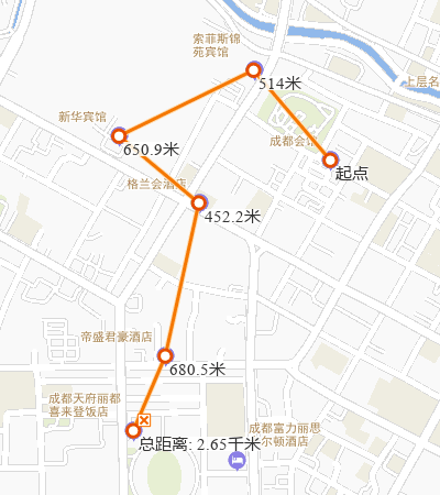
Distance Measure
Distance measurement includes three types: straight line, geodesic line, and raster surface distance:
- Euclidean Distance refers to the horizontal distance between any two points in 2D planar space, disregarding Earth's curvature.
- Geodesic Distance refers to the shortest path length between two points on an ellipsoidal Earth surface. For example, it can measure the shortest path between city airports as flight routes.
- Surface Distance refers to measuring terrain surface distance along specified lines or polylines on 3D surfaces fitted by raster data. Surface measurements are longer than Euclidean and geodesic distances.
The following demonstrates Euclidean Distance measurement:
- Select Euclidean Distance from the Map Measurement dropdown. The cursor becomes crosshairs.
- Left-click the starting point. A temporary line with dynamic length appears, showing distance value.
- Move the mouse to the second point and left-click.
 Note:
Note:Two values display during measurement: segment length between current point and previous point, and total polyline length from start point.
- Before clicking the second point, both values are equal.
- After clicking the second point, values differ during mouse movement.
- Segment length is always less than total polyline length.
- Repeat step 3 to add points. Right-click to finish.
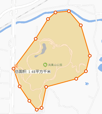
Area Measure
Area measurement includes planar area and surface area. Surface area measures terrain surfaces fitted by raster data. Planar area measurement example:
- Select Area from Map Measurement dropdown. Cursor becomes crosshairs.
- Left-click the area boundary's starting point.
- Left-click boundary node to draw polygon vertices.
- Repeat step 3. Right-click to complete polygon.
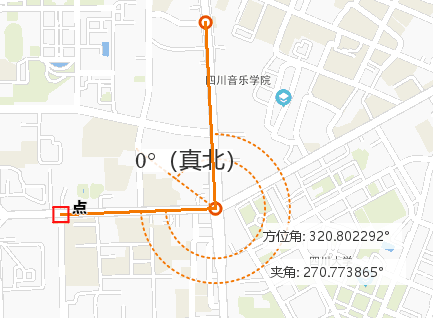
Angle Measure
Used to measure angles between consecutive line segments.
- Select Angle from Map Measurement dropdown. Cursor becomes crosshairs.
- Left-click a point on one side of the angle as the start point. A dashed line pointing true north appears. Moving the mouse creates a ray showing azimuth angle.
- Move and left-click the vertex. A ray from the vertex forms an angle with the first edge, displaying angle value and current ray's azimuth.
- Left-click a point on the other side.
- Repeat steps 3-4 for continuous measurements.
- Right-click to finish.
Clear
Click Clear in MapsActions group or press Esc key to remove all measurement results.
Related Topics