


Function Description
The 'calculate raster statistics' command is used to compute raster values in a raster dataset, facilitating users to view the specific single-value distribution of raster values.
 Note:
Note:This command is only effective for raster datasets (i.e., Grid data). For image datasets (such as raster data in Image format), 'calculate raster statistics' cannot be performed. Therefore, this class of datasets does not have the 'calculate raster statistics' option in the context menu.
This feature is similar to the raster histogram, both computing raster values in a raster dataset. Unlike the raster histogram, which displays frequency distributions and data grouped by intervals for a specific field, 'calculate raster statistics' computes the count of specific raster values in the raster dataset.
Feature Entry
- Workspace Manager->raster dataset node context menu->Calculate Raster Statistics option.
Steps
- Right-click to select a Raster Dataset node in the workspace manager that requires 'calculate raster statistics' (or select multiple dataset nodes, then right-click). In the pop-up context menu, choose the Calculate Raster Statistics command. The system will compute the raster values for the selected raster dataset.
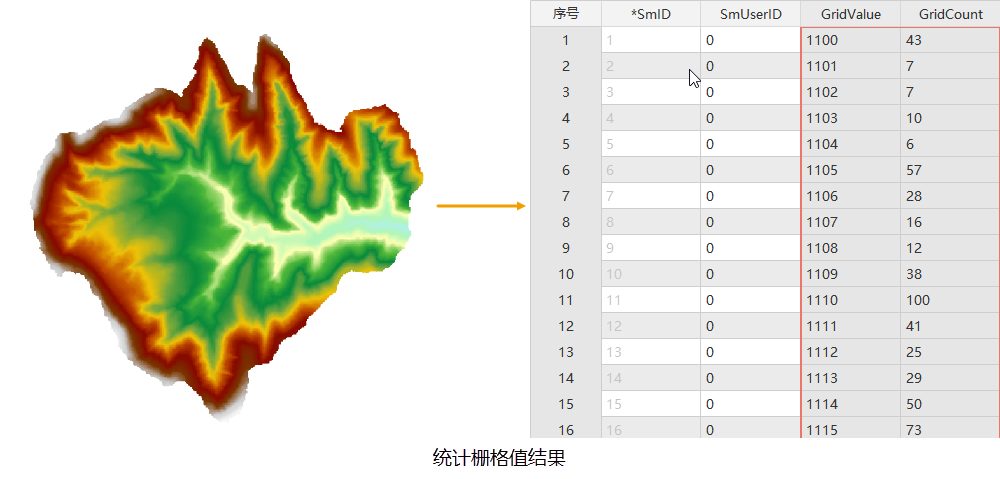
- Upon successful computation, a count will automatically pop up. The result data is an attribute table, which records the computed raster values and their single-value quantities, as shown in the figure below.
Related Topics
recalculate extent/length/perimeter and area