Flight management
Analysis management is to determine the flight route by setting a series of flight stations and related information in advance, and then execute flight browsing operation, that is, to realize automatic browsing of scenes according to the determined flight route.
Currently, this product provides import of existing flight path files to achieve flight browsing.
 |
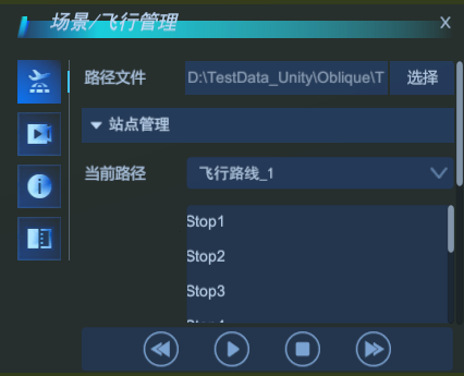
| Flight management interface |
Import an existing flight path file
With this mode, you can import existing flight path files and set up site and camera parameters.
- Existing flight path files can be generated via SuperMap iDesktop/iDesktopX.
- Click Scene -> Flight Management to pop up the Flight Management Panel and select Import Path.
- Click Select to pop up the Choose File dialog box, select the flight path file *.fpf, and click Open .
- When you import an existing flight path file, the dashboard displays information about it. Click to select any station, and the parameter information of the corresponding station will be displayed in the camera parameter setting bar, including: the flight time from the current station to the next station, the observation point position (longitude, latitude, altitude), the observation azimuth angle, and the observation inclination angle. Each parameter value of the site can be modified according to requirements.
- You can navigate to the corresponding site to view through the positioning button behind each site, and delete the corresponding site through the delete button.
- The New button in the Site Management bar allows you to create a new site based on the current camera viewpoint and supports setting and modifying site parameters.
- Start, pause, or stop flying is controlled by the bottom buttons, and flight can be controlled by the forward and backward buttons.

Give a typical example
An example of scene browsing based on flight management is shown in the figure below.
 |
| Flight Management Example |


