

URI
<networkService_uri>/{routeLayerName}/solve[.<format>]
支持的方法
父资源
介绍
最佳路径分析 。
支持的方法:
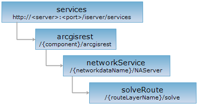
资源层次
HTTP 请求方法
对如下 URI 执行 HTTP 请求,以 json 输出格式为例加以说明,其中,supermapiserver 是服务器名,{component}是服务组件名,{networkdataName}是网络数据名,{routeLayerName}是路径图层名。
http://supermapiserver:8090/iserver/services/{component}/arcgisrest/{networkdataName}/NAServer/{routeLayerName}/solve.json
GET 请求
对 solveRoute 资源执行 GET 请求,可以获取最佳路径分析结果。
请求参数
对 solveRoute 资源执行 GET 请求,获取最佳路径分析结果,可以在 URI 中包含如下参数
| 名称 | 类型 | 含义 |
| f | String | 响应格式,支持 json、pjson |
| stops | Point2D[] | 【必需】 指定要在其间查找路线的两个及以上的位置 |
| barriers | Point2D[] | 障碍点集合 |
| impedanceAttributeName | impedanceAttributeName | 权值字段 |
| ReturnDirections | boolean | 是否返回方向,默认为 true |
| ReturnRoutes | boolean | 是否返回路线,默认为 true |
| ReturnStops | boolean | 是否返回查询位置 |
| ReturnBarriers | boolean | 是否返回障碍点 |
| outSR | String | 输出坐标系 |
响应结构
对 solveRoute 资源执行 GET 请求,返回的资源表述的结构如下
| 字段 | 类型 | 说明 |
| stops | PointSet | 事件点 |
| barriers | PointSet | 障碍点 |
| routes | Routes | 路线 |
| messages | String[] | 信息 |
| directions | Direction[] | 方向 |
响应示例
对 solveRoute 资源:http://localhost:8091/iserver/services/transportationAnalyst-Changchun/arcgisrest/RoadNet@Changchun/NAServer/routeLayer/solve?f=pjson&stops=70.1515638201,-54.7406354454;550.6770595320,56.1050211383&barriers=null&impedanceAttributeName=null&returnDirections=true&returnRoutes=true 执行 GET 请求,返回的 pjson 格式的表述如下:
{
"routes": {
"features": [{
"attributes": {},
"geometry": {
"paths": [[
[
70.1515638200593,
-54.7406354454158
],
[
76.18348947781757,
-134.92485855116797
],
[
111.01197574440013,
-124.66628623264731
],
[
119.61003975513272,
-122.62783944590828
],
[
161.09530379013117,
-112.79242730387216
],
[
171.90355999452908,
-113.24911418574811
],
[
183.92964788392953,
-117.96821196513312
],
[
199.15254394646175,
-120.86056221701423
],
[
231.88177048090608,
-119.9471884532623
],
[
299.3192000379238,
-106.55103991823394
],
[
363.1031345399339,
-88.43579360382057
],
[
367.8222323193189,
-87.52241984006864
],
[
376.9559699568382,
-86.6090460763167
],
[
401.61706157814046,
-83.86892478506093
],
[
413.03423362503963,
-82.3466351788077
],
[
425.3647794356907,
-78.54091116317464
],
[
434.3462881125848,
-76.2574767537948
],
[
458.0940059701351,
-75.19187402941755
],
[
510.15631050399526,
-73.51735546253899
],
[
525.7717933539819,
-72.03388459179025
],
[
540.6021026290597,
-70.62500521065787
],
[
552.0074139469053,
-71.40708370102442
],
[
550.6770595319997,
-56.10502113825084
]
]],
"spatialReference": null
}
}],
"spatialReference": {},
"geometryType": "esriGeometryPolyline"
},
"barriers": null,
"directions": [{
"summary": {
"envelope": {
"ymin": -134.92485855116797,
"xmin": 70.1515638200593,
"ymax": 56.1050211383,
"xmax": 552.0074139469053,
"spatialReference": null
},
"totalTime": 0,
"totalLength": 580.9501814184109
},
"features": [
{
"compressedGeometry": "+9h5k0+kt0hrm-ga1ggi",
"attributes": {
"length": 0,
"maneuverType": "esriDMTStop",
"time": 0,
"text": "从此处出发"
}
},
{
"compressedGeometry": "+9h5k0+kt0hrm-ga1ggi+1pgpgo-nsm91n",
"attributes": {
"length": 80.41078138044527,
"maneuverType": "esriDMTUnknown",
"time": 0,
"text": "向南80.41078138044527米"
}
},
{
"compressedGeometry": "+9h5k0+mmhbce-186npi9",
"attributes": {
"length": 0,
"maneuverType": "esriDMTTurnLeft",
"time": 0,
"text": "左转"
}
},
{
"compressedGeometry": "+9h5k0+mmhbce-186npi9+ac4ptv+31qlbq+2hvtf0+je2mk",
"attributes": {
"length": 45.14427493765779,
"maneuverType": "esriDMTUnknown",
"time": 0,
"text": "向东45.14427493765779米"
}
},
{
"compressedGeometry": "+9h5k0+13km2pd-14hf1fq",
"attributes": {
"length": 0,
"maneuverType": "esriDMTStraight",
"time": 0,
"text": "继续前行"
}
},
{
"compressedGeometry": "+9h5k0+13km2pd-14hf1fq+cbk9h0+2tpgu8+372dc2-4bbqj",
"attributes": {
"length": 53.45312584077624,
"maneuverType": "esriDMTUnknown",
"time": 0,
"text": "向东53.45312584077624米"
}
},
{
"compressedGeometry": "+9h5k0+1j7cpmf-11o0sc5",
"attributes": {
"length": 0,
"maneuverType": "esriDMTStraight",
"time": 0,
"text": "继续前行"
}
},
{
"compressedGeometry": "+34+gp6-b1s+15i-eo+1fj-92+369+2r+6in+19r+67b+1ok+eo+2r+sh+2s+2d2+8i+13m+4o+16h+bs+s2+75+2a7+3a",
"attributes": {
"length": 292.47802422615524,
"maneuverType": "esriDMTUnknown",
"time": 0,
"text": "向东292.47802422615524米"
}
},
{
"compressedGeometry": "+34+1cnh-7av",
"attributes": {
"length": 0,
"maneuverType": "esriDMTStraight",
"time": 0,
"text": "继续前行"
}
},
{
"compressedGeometry": "+34+1cnh-7av+52m+57+1gq+4k",
"attributes": {
"length": 67.7750164083581,
"maneuverType": "esriDMTUnknown",
"time": 0,
"text": "向东67.7750164083581米"
}
},
{
"compressedGeometry": "+34+1jb1-713",
"attributes": {
"length": 0,
"maneuverType": "esriDMTStraight",
"time": 0,
"text": "继续前行"
}
},
{
"compressedGeometry": "+34+1jb1-713+1eb+4c+13k-2d",
"attributes": {
"length": 26.32917472210179,
"maneuverType": "esriDMTUnknown",
"time": 0,
"text": "向东26.32917472210179米"
}
},
{
"compressedGeometry": "+34+1lt0-6v4",
"attributes": {
"length": 0,
"maneuverType": "esriDMTTurnLeft",
"time": 0,
"text": "左转"
}
},
{
"compressedGeometry": "+34+1lt0-6v4-44+1fp",
"attributes": {
"length": 15.35978390291659,
"maneuverType": "esriDMTUnknown",
"time": 0,
"text": "向北15.35978390291659米"
}
},
{
"compressedGeometry": "+34+1lor-5fa",
"attributes": {
"length": 0,
"maneuverType": "esriDMTStraight",
"time": 0,
"text": "继续前行"
}
},
{
"compressedGeometry": "+34+1lor-5fa+0+auk",
"attributes": {
"length": 0,
"maneuverType": "esriDMTUnknown",
"time": 0,
"text": "向北"
}
},
{
"compressedGeometry": "+34+1lor+5fa",
"attributes": {
"length": 0,
"maneuverType": "esriDMTStop",
"time": 0,
"text": "到达路由点2"
}
}
]
}],
"messages": [],
"stops": null
}
POST 请求
跟 GET 请求结构类似。
HEAD 请求
返回跟 GET 请求一样的 HTTP 响应头,但是没有响应实体。可以在不必传输整个响应内容的情况下,获取包含在响应消息头中的元数据信息。元数据信息包括媒体类型,字符编码,压缩编码,实体内容长度等。
HEAD 请求可以用来判断 solveRoute 资源是否存在,或者客户端是否有权限访问 solveRoute 资源。通过对加.<format>的 URI 执行 HEAD 请求,还可以快速判断 solveRoute 资源是否支持<format>格式的表述。
请参见