

URI
<networkService_uri>/{closestFacilityLayerName}/solveClosestFacility[.<format>]
支持的方法
父资源
介绍
最近设施分析 。
支持的方法:
- GET:获取最近设施分析结果。
- POST:根据给定条件,创建最近设施分析结果。
- HEAD:检查 solveClosestFacility 资源是否存在,或权限是否可以访问 solveClosestFacility 资源。
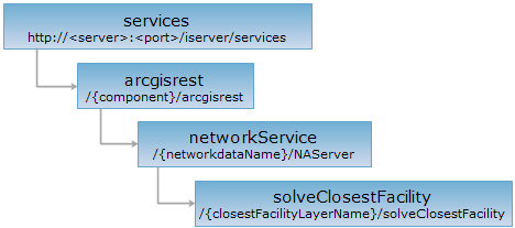
资源层次
HTTP 请求方法
对如下 URI 执行 HTTP 请求,以 json 输出格式为例加以说明,其中,supermapiserver 是服务器名,{component}是服务组件名,{networkdataName}是网络数据名,{closestFacilityLayerName}是最近设施图层名。
http://supermapiserver:8090/iserver/services/{component}/arcgisrest/{networkdataName}/NAServer/{closestFacilityLayerName}/solveClosestFacility.json
GET 请求
请求参数
| 名称 | 类型 | 含义 |
| incidents | Point2D[] | 【必需】 要搜索附近位置的一个或多个点,称为事件点 |
| facilities | Point2D[] | 【必需】 在查找最近位置时要搜索的一个或多个点,称为设施点 |
| defaultTargetFacilityCount | int | 【必需】 要查找的设施点数量,必须大于零 |
| travelDirection | String | 分析方向 |
| defaultCutOff | double | 结束查找的半径或时间 |
| barriers | Point2D[] | 障碍点集合 |
| impedanceAttributeName |
String |
权值字段 |
| returnDirections | boolean | 是否返回方向 |
|
returnCFRoutes |
boolean | 是否返回路由 |
| returnFacilities | boolean | 是否返回设施点 |
| returnIncidents | boolean | 是否返回事件点 |
| returnBarriers | boolean | 是否返回障碍点 |
| outSR | String | 输出坐标系 |
响应结构
对 solveClosestFacility 资源执行 GET 请求,返回的资源表述的结构如下:
| 字段 | 类型 | 说明 |
| facilities | PointSet | 设施点 |
| incidents | PointSet | 事件点 |
| barriers | PointSet | 障碍点 |
| routes | Routes | 路线 |
| messages | String[] | 信息 |
| directions | Direction[] | 方向 |
响应示例
对 olveClosestFacility 资源:http://localhost:8091/iserver/services/transportationAnalyst-Changchun/arcgisrest/RoadNet@Changchun/NAServer/closestFacilityLayer/solveClosestFacility?f=pjson&barriers=null&incidents=119.6100397551,-122.6278394459&facilities=70.1515638201,-54.7406354454;550.6770595320,-56.1050211383;445.6471889264,-229.2074549041&impedanceAttributeName=null&returnDirections=true&returnCFRoutes=true&defaultTargetFacilityCount=1&travelDirection=esriNATravelDirectionFromFacility&defaultCutOff=null 执行 GET 请求,返回的 pjson 格式的表述如下:
{
"routes": {
"features": [{
"attributes": null,
"geometry": {
"paths": [[
[
70.1515638200593,
-54.7406354454158
],
[
76.18348947781757,
-134.92485855116797
],
[
111.01197574440013,
-124.66628623264731
],
[
119.61003975513272,
-122.62783944590828
]
]],
"spatialReference": {}
}
}],
"spatialReference": {},
"geometryType": "esriGeometryPolyline"
},
"barriers": null,
"directions": [{
"summary": {
"envelope": {
"ymin": -134.92485855116797,
"xmin": 70.1515638200593,
"ymax": -54.7406354454,
"xmax": 119.61003975513272,
"spatialReference": null
},
"totalTime": 125.55505631810306,
"totalLength": 125.55505631810306
},
"features": [
{
"compressedGeometry": "+9h5k0+kt0hrm-ga1ggi",
"attributes": {
"length": 0,
"maneuverType": "esriDMTStop",
"time": 0,
"text": "从此处出发"
}
},
{
"compressedGeometry": "+9h5k0+kt0hrm-ga1ggi+1pgpgo-nsm91n",
"attributes": {
"length": 80.41078138044527,
"maneuverType": "esriDMTUnknown",
"time": 80.41078138044527,
"text": "向南80.41078138044527米"
}
},
{
"compressedGeometry": "+9h5k0+mmhbce-186npi9",
"attributes": {
"length": 0,
"maneuverType": "esriDMTTurnLeft",
"time": 0,
"text": "左转"
}
},
{
"compressedGeometry": "+9h5k0+mmhbce-186npi9+ac4ptv+31qlbq+2hvtf0+je2mk",
"attributes": {
"length": 45.14427493765779,
"maneuverType": "esriDMTUnknown",
"time": 45.14427493765779,
"text": "向东45.14427493765779米"
}
},
{
"compressedGeometry": "+9h5k0+13km2pd-14hf1fq",
"attributes": {
"length": 0,
"maneuverType": "esriDMTStop",
"time": 0,
"text": "到达路由点2"
}
}
]
}],
"incidents": null,
"messages": [],
"facilities": null
}
POST 请求
跟 GET 请求结构类似。
HEAD 请求
返回跟 GET 请求一样的 HTTP 响应头,但是没有响应实体。可以在不必传输整个响应内容的情况下,获取包含在响应消息头中的元数据信息。元数据信息包括媒体类型,字符编码,压缩编码,实体内容长度等。
HEAD 请求可以用来判断 solveClosestFacility 资源是否存在,或者客户端是否有权限访问 solveClosestFacility 资源。通过对加.<format>的 URI 执行 HEAD 请求,还可以快速判断 solveClosestFacility 资源是否支持<format>格式的表述。
请参见