In SuperMap iServer, a GIS service corresponds to a service instance. The service instance is used for receiving and processing client requests to implement GIS functions and respond results to client.
SuperMap iServer contains three-layer structure: service provider layer, service component layer, and service interface layer (see SuperMap iServer Architecture). The loose GIS functions from different sources in the service provider layer are encapsulated into the coarse-grained module, and find a proper specification in the service interface layer to organize service instances. Thus the GIS functions will be provided in the form of network service. It is shown as follows:
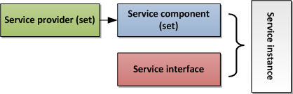
The configuration and management of GIS services is to configure and manage all parts of contents when publishing GIS services.
- Configuring and managing service instances
- Relationship diagram
- Workspace(only for SuperMap iServer)
- Configuration for each layer of iServer architecture
- Configuration for service aggregation
- Configuration multi-process in single machine(only for SuperMap iServer)