URI
<networkDataName_uri_uri>/tracedown[.<format>]
Supported methods
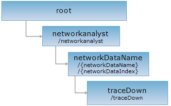
Parent resource
Introduction
traceDown resource represents tracing downstream analysis. By sending a GET request to traceDown, the system will return the downstream arcs and nodes that flow from the specified arcs or nodes.
Supported Methods:
- GET: Finds the downstream arcs and nodes that flow from the specified arcs or nodes.
- HEAD: Checks whether the traceDown resource exists, or if the current user has the authority to access the traceDown resource.
Supported output formats: RJSON, JSON, HTML, XML.
Resource hierarchy
HTTP request methods
Execute HTTP request on the following URI, here we take rjosn as the output format as an example. Where, supermapiserver is the server name.
http://supermapiserver:8090/iserver/services/transportationAnalyst-facilityNet/rest/networkanalyst/WaterNet@FacilityNet/tracedown.rjson
GET 请求
request
Finds the upstream arcs and nodes that flow from the specified arcs or nodes.
Request parameter
To execute a GET request on traceDown resource, the URI should contain the following parameters:
| Name | Type | Description |
| edgeID | int | [One of edgeID and nodeID is required] The specified edge ID used to find it's downstream facilities. |
| nodeID | int | [One of edgeID and nodeID is required] The specified node ID used to find it's downstream facilities. |
| weightName | String | Weight field. Default is SMLENGTH. |
| isUncertainDirectionValid | boolean |
true indicates uncertain flow direction is valid, the arcs with uncertain flow direction still participates in the analysis; false means uncertain flow direction is invalid, ie., the system will stop searching in that direction when the dirction is uncertain. |
| returnFeatures | boolean |
Whether to return the detailed information of the result features. False means only the IDs of the result features will be returned. |
Response structure
After executing tracing downstream analysis, the response fields of the result representation are as follows:
| Name | Type | Description |
| cost | double | The cost of the tracing analysis. |
| edges | int[] | The IDs of the result edges. |
| edgesFeatures | Feature[] | The detailed information of the result edges. |
| nodes | int[] | The IDs of the result nodes. |
| nodesFeature | Feature[] | The detailed information of the result nodes. |
Response example
Execute tracing downstream analysis to sample dataset "WaterNet@FacilityNet", ie., sending a GET request by using the following URI:
http://supermapiserver:8090/iserver/services/transportationAnalyst-facilityNet/rest/networkanalyst/WaterNet@FacilityNet/tracedown.rjson?edgeID=1&isUncertainDirectionValid=true&returnFeatures=true&weightName=SMLENGTH
Analysis result:
{
"cost": 490392.3672126023,
"edges": [
1,
2,
2
],
"edgesFeatures": [
{
"ID": 1,
"fieldNames": [
"SMID",
"SMSDRIW",
"SMSDRIN",
"SMSDRIE",
"SMSDRIS",
"SMUSERID",
"SMRESISTANCEA",
"SMRESISTANCEB",
"SMLENGTH",
"SMTOPOERROR",
"SMFNODE",
"SMTNODE",
"SMEDGEID",
"SMGEOMETRYSIZE",
"DIRECTION"
],
"fieldValues": [
"1",
"-948942.3",
"3856350.0",
"-926875.44",
"3791757.5",
"3332",
"1.0",
"1.0",
"82880.9632134468",
"1",
"2",
"7",
"1",
"632",
"1"
],
"geometry": {
"center": {
"x": -926972.563544177,
"y": 3826413.0521438215
},
"id": 1,
"partTopo": null,
"parts": [39],
"points": [
{
"x": -941483.7569166485,
"y": 3856349.8855158235
},
{
"x": -942765.4042135794,
"y": 3853741.8282586816
},
{
"x": -943883.8576401076,
"y": 3851853.94355556
},
{
"x": -944163.6582859682,
"y": 3849501.8216074924
},
{
"x": -943682.0625984033,
"y": 3848103.741719451
},
{
"x": -942896.95807764,
"y": 3846722.2000929313
},
{
"x": -941486.8876817955,
"y": 3845068.129615492
},
{
"x": -939929.5695138746,
"y": 3844437.836164761
},
{
"x": -938168.7730279022,
"y": 3843818.4586299863
},
{
"x": -933916.5052925996,
"y": 3842211.0133842216
},
{
"x": -932983.020075049,
"y": 3841852.605190063
},
{
"x": -931956.7262807183,
"y": 3839772.193372
},
{
"x": -931443.1132447799,
"y": 3837766.41048471
},
{
"x": -931073.2835533952,
"y": 3836565.856309187
},
{
"x": -929962.6060571494,
"y": 3834794.6863347134
},
{
"x": -929176.6882087882,
"y": 3833412.885338366
},
{
"x": -927879.8650005814,
"y": 3831955.9660093724
},
{
"x": -926875.4594167685,
"y": 3830280.228622274
},
{
"x": -926883.7482657861,
"y": 3828551.9486851217
},
{
"x": -926972.563544177,
"y": 3826413.0521438215
},
{
"x": -927865.6994237883,
"y": 3824130.405792608
},
{
"x": -928627.8684607756,
"y": 3823175.8246027
},
{
"x": -929884.876685566,
"y": 3821992.3630313408
},
{
"x": -931952.1577797777,
"y": 3820766.421233274
},
{
"x": -934414.5315977258,
"y": 3819316.906936594
},
{
"x": -936386.3225472053,
"y": 3818197.6277481425
},
{
"x": -937441.5077787752,
"y": 3817024.198449457
},
{
"x": -938729.4167850106,
"y": 3814517.595375112
},
{
"x": -939830.2433983588,
"y": 3812326.4907802665
},
{
"x": -941962.1487272659,
"y": 3810385.2249598163
},
{
"x": -944119.7861036116,
"y": 3808951.710151221
},
{
"x": -945569.0461299194,
"y": 3807554.3591885213
},
{
"x": -947538.7330514987,
"y": 3804504.4852072173
},
{
"x": -948352.7391655098,
"y": 3802632.3853419162
},
{
"x": -948942.3154318775,
"y": 3800365.279127587
},
{
"x": -948876.7589196367,
"y": 3799149.4491934534
},
{
"x": -948576.0448517092,
"y": 3797335.61439268
},
{
"x": -948371.5294164096,
"y": 3795415.281548102
},
{
"x": -947728.2672767679,
"y": 3791757.5905491877
}
],
"prjCoordSys": null,
"style": null,
"type": "LINE"
}
},
{
"ID": 2,
"fieldNames": [
"SMID",
"SMSDRIW",
"SMSDRIN",
"SMSDRIE",
"SMSDRIS",
"SMUSERID",
"SMRESISTANCEA",
"SMRESISTANCEB",
"SMLENGTH",
"SMTOPOERROR",
"SMFNODE",
"SMTNODE",
"SMEDGEID",
"SMGEOMETRYSIZE",
"DIRECTION"
],
"fieldValues": [
"2",
"-1130331.0",
"3830856.5",
"-947728.25",
"3791757.5",
"3331",
"1.0",
"1.0",
"203755.70199957775",
"1",
"1",
"7",
"2",
"1128",
"2"
],
"geometry": {
"center": {
"x": -1032342.2904773944,
"y": 3830365.2858050363
},
"id": 2,
"partTopo": null,
"parts": [70],
"points": [
{
"x": -1130330.9808985773,
"y": 3829150.748031182
},
{
"x": -1128234.7904652364,
"y": 3828104.009454467
},
{
"x": -1126255.1325870433,
"y": 3827191.2146250424
},
{
"x": -1122147.7608089868,
"y": 3826389.2424355363
},
{
"x": -1118996.4354008625,
"y": 3826349.818749717
},
{
"x": -1116633.011077165,
"y": 3825863.564885844
},
{
"x": -1112647.1905697775,
"y": 3823530.7633450227
},
{
"x": -1109404.8613276782,
"y": 3823699.9458534885
},
{
"x": -1104963.4434357388,
"y": 3824236.9347074623
},
{
"x": -1103095.9252104952,
"y": 3823521.1464944556
},
{
"x": -1101196.1951914872,
"y": 3822197.7651115553
},
{
"x": -1098288.6053171528,
"y": 3821027.851704959
},
{
"x": -1095832.1990014191,
"y": 3822578.9350222354
},
{
"x": -1093939.1641607706,
"y": 3823288.186820875
},
{
"x": -1089976.8523173246,
"y": 3823290.9789834903
},
{
"x": -1086937.4282131107,
"y": 3823449.774688991
},
{
"x": -1083262.9294079782,
"y": 3823133.4122251435
},
{
"x": -1080308.5822595612,
"y": 3822982.831215473
},
{
"x": -1078235.039456045,
"y": 3824107.3188307434
},
{
"x": -1074918.6602512866,
"y": 3824788.8615466543
},
{
"x": -1070455.5874198638,
"y": 3824919.863382298
},
{
"x": -1067245.7101189618,
"y": 3825697.427543476
},
{
"x": -1064819.9154555884,
"y": 3825925.5840080306
},
{
"x": -1062809.7304527196,
"y": 3826335.4115854916
},
{
"x": -1060473.8727126697,
"y": 3826355.6158234435
},
{
"x": -1058230.3011492807,
"y": 3828099.3509229296
},
{
"x": -1054952.5848149788,
"y": 3829489.731349712
},
{
"x": -1051625.6774255729,
"y": 3829968.265531121
},
{
"x": -1047545.0995276025,
"y": 3829673.290573323
},
{
"x": -1044249.4125167541,
"y": 3828829.0674762647
},
{
"x": -1042493.8496550785,
"y": 3828310.5953339576
},
{
"x": -1041165.826380332,
"y": 3828176.832533287
},
{
"x": -1039155.6566114768,
"y": 3828586.9595481395
},
{
"x": -1035916.0248894612,
"y": 3830686.606986321
},
{
"x": -1034604.3518378383,
"y": 3830856.5284370193
},
{
"x": -1032342.2904773944,
"y": 3830365.2858050363
},
{
"x": -1028336.6603973655,
"y": 3829557.9055637843
},
{
"x": -1022852.5477079265,
"y": 3827709.800223688
},
{
"x": -1018665.7468791755,
"y": 3827318.389545431
},
{
"x": -1016111.2374263101,
"y": 3827045.36609677
},
{
"x": -1014350.740225432,
"y": 3826425.973536659
},
{
"x": -1013228.427009851,
"y": 3824451.650495656
},
{
"x": -1009849.8947843194,
"y": 3822087.1597893927
},
{
"x": -1006175.5904245786,
"y": 3821770.687496191
},
{
"x": -1003343.990563439,
"y": 3822019.717379139
},
{
"x": -998459.1918259463,
"y": 3821868.487222808
},
{
"x": -996184.2784175407,
"y": 3819243.2520305067
},
{
"x": -993627.724074437,
"y": 3817038.830280837
},
{
"x": -991616.0285358524,
"y": 3815517.9332023095
},
{
"x": -989677.3802649409,
"y": 3813484.626188326
},
{
"x": -987073.9536520431,
"y": 3812299.242406637
},
{
"x": -985356.8102337797,
"y": 3812490.72093764
},
{
"x": -982632.4309204014,
"y": 3812836.136456593
},
{
"x": -981320.3740559996,
"y": 3813006.377378464
},
{
"x": -978793.3263470794,
"y": 3813239.7172276108
},
{
"x": -975107.3118963279,
"y": 3812720.595938644
},
{
"x": -971150.6936600255,
"y": 3812825.47120951
},
{
"x": -968125.6205907371,
"y": 3811357.451177546
},
{
"x": -966017.596189799,
"y": 3809942.458276486
},
{
"x": -963306.8848134733,
"y": 3808661.392554484
},
{
"x": -961428.3700631196,
"y": 3807743.219723986
},
{
"x": -960120.220576681,
"y": 3806083.3319280534
},
{
"x": -959135.954318631,
"y": 3802882.7570908335
},
{
"x": -956872.1270410249,
"y": 3800459.701882651
},
{
"x": -953579.0758960873,
"y": 3797785.9142398983
},
{
"x": -952010.252238556,
"y": 3796953.061588975
},
{
"x": -951309.5905573696,
"y": 3795261.474610711
},
{
"x": -950335.7374882551,
"y": 3792263.6138790464
},
{
"x": -948180.5669224514,
"y": 3791868.173033622
},
{
"x": -947728.2672767679,
"y": 3791757.5905491877
}
],
"prjCoordSys": null,
"style": null,
"type": "LINE"
}
},
null
],
"nodes": [
7,
2,
1
],
"nodesFeatures": [
{
"ID": 7,
"fieldNames": [
"SMID",
"SMX",
"SMY",
"SMLIBTILEID",
"SMNODEID",
"SMUSERID",
"SMGEOMETRYSIZE",
"NODETYPE",
"FILTER"
],
"fieldValues": [
"7",
"-947728.2672767679",
"3791757.5905491877",
"1",
"7",
"0",
"16",
"0",
"true"
],
"geometry": {
"center": {
"x": -947728.2672767679,
"y": 3791757.5905491877
},
"id": 7,
"partTopo": null,
"parts": [1],
"points": [{
"x": -947728.2672767679,
"y": 3791757.5905491877
}],
"prjCoordSys": null,
"style": null,
"type": "POINT"
}
},
{
"ID": 2,
"fieldNames": [
"SMID",
"SMX",
"SMY",
"SMLIBTILEID",
"SMNODEID",
"SMUSERID",
"SMGEOMETRYSIZE",
"NODETYPE",
"FILTER"
],
"fieldValues": [
"2",
"-941483.7569166485",
"3856349.8855158235",
"1",
"2",
"0",
"16",
"0",
"true"
],
"geometry": {
"center": {
"x": -941483.7569166485,
"y": 3856349.8855158235
},
"id": 2,
"partTopo": null,
"parts": [1],
"points": [{
"x": -941483.7569166485,
"y": 3856349.8855158235
}],
"prjCoordSys": null,
"style": null,
"type": "POINT"
}
},
{
"ID": 1,
"fieldNames": [
"SMID",
"SMX",
"SMY",
"SMLIBTILEID",
"SMNODEID",
"SMUSERID",
"SMGEOMETRYSIZE",
"NODETYPE",
"FILTER"
],
"fieldValues": [
"1",
"-1130330.9808985773",
"3829150.748031182",
"1",
"1",
"0",
"16",
"0",
"true"
],
"geometry": {
"center": {
"x": -1130330.9808985773,
"y": 3829150.748031182
},
"id": 1,
"partTopo": null,
"parts": [1],
"points": [{
"x": -1130330.9808985773,
"y": 3829150.748031182
}],
"prjCoordSys": null,
"style": null,
"type": "POINT"
}
}
]
}
HEAD request
Returns the same HTTP response header as the GET request, but no response entity, which can be used to retrieve the meta data contained in response message header without having to transmit the entire response content. Meta data information includes media type, character coding, compression coding, entity content length, etc.
HEAD request is used to determine whether the traceDown resource exists, or if the user has the authority to access it. By executing an HEAD request with a .<format> URI, you can quickly determine whether the traceDown resource supports the <format> representation.