

URI
<portal_uri>/administrativedivisions/{A3Code}/{adcode}[.<format>]
Supported methods
Parent resource
Introduction
The administrativeDivRegion resource represents the vector polygon resource corresponding to the vector division of an administrative division. By sending a GET request, you can retrieve the vector polygon corresponding to the vector division of an administrative division.
Supported methods:
- GET:Retrieves the vector polygon corresponding to the vector division of an administrative division.
- HEAD:Checks whether the administrativeDivRegion resource exists, or whether the permission can access the administrativeDivRegion resource.
Supported output formats: RJSON, JSON, XML.
Resource hierarchy
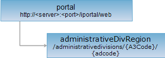
HTTP request methods
Perform an HTTP request on the following URI, using rjson output format as an example, where supermapiportal is the server name, {A3Code} is a 3-letter international domain code, and {adcode} is the administrative division code.
http://supermapiportal:8190/iportal/web/administrativedivisions/{A3Code}/{adcode}.rjson
GET request
Retrieves the vector polygon corresponding to the vector division of an administrative division.
Request parameters
If no parameters are set, the administrative vector division polygon is returned by default in the WGS 84 coordinate system (EPSG Code: 4326). After setting parameters, the vector division polygon is returned in the user-specified coordinate system. Request parameters must be included in the URI.
| Name | Type | Description |
| prjCoordSys | PrjCoordSys | The specified coordinate reference system. |
Response structure
Performing a GET request on the administrativeDivRegion resource. The representation structure of the returned vector polygon object is as follows:
| Field | Type | Description |
| id | int | The unique identifier of the geometry object. |
| center | Point2D | The center point of the geometry object. |
| parts | int[] | The number of nodes contained in each sub-object of the geometry object. |
| partTopo | int[] | The topology structure of the part. 1 represents an island, -1 represents a hole. |
| points | Point2D[] | The array of 2D coordinate pairs of the nodes that make up the geometry object. |
| prjCoordSys | PrjCoordSys | The projected coordinate system of the geometry object. |
| style | Style | The style of the geometry object. |
| type | GeometryType | The type of the geometry object. The type of vector polygons corresponding to administrative divisions is: Region. |
Response example
Performing a GET request on the administrativeDivRegion resource. The rjson format response is as follows:
HEAD request
Returns the same HTTP response headers as a GET request, but without the response entity. Metadata information contained in the response headers can be obtained without transferring the entire response content. Metadata includes media type, character encoding, content encoding, and content length.
HEAD requests can be used to determine whether the administrativeDivRegion resource exists or whether the client has permission to access the administrativeDivRegion resource. By performing a HEAD request on a URI with .<format>, you can also quickly determine whether the administrativeDivRegion resource supports the <format> format representation.
See