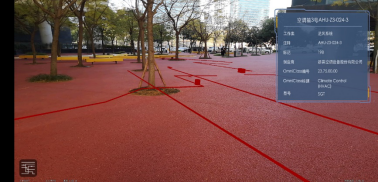
Domestic water, electricity, gas, network, and other pipelines are deeply buried under the city, forming an intricate network of urban pipelines, like an underground labyrinth. These pipelines belong to different units and lack unified planning and data association. In addition, problems such as lack of scientific supervision and irregular construction process lead to frequent safety accidents, which seriously threaten life and property safety, and are not conducive to urban management.
SuperMap iMobile (hereinafter, “iMobile”) loads 3D pipeline models into AR scenes, making the pipeline configuration diagram three-dimensional, thereby helping users perform intelligent pipeline management more accurately and efficiently.
The AR module of iMobile is mainly based on the ARCore platform, supplemented by the self-developed SLAM platform, and adopts a multi-modal integration method. iMobile’s 3D can access BIM data from multiple manufacturers, such as AutoDesk Revit, Bentley, CATIA, SketchUp, PKPM, Glodon, etc. It can also perform multi-source data matching, integrating TIN terrain, oblique photographic models, videos, sensors, etc. . The combination of AR and 3D applies to develop a pipeline inspection and management APP for mobile phones or tablet computers with an Android operating system.
 |
| Figure: AR Pipeline Management |


