Indoor-outdoor Navigation (naviintegration)
Introduction
Demonstration and use of industry navigation module to achieve indoor and outdoor incremental integrated path navigation.
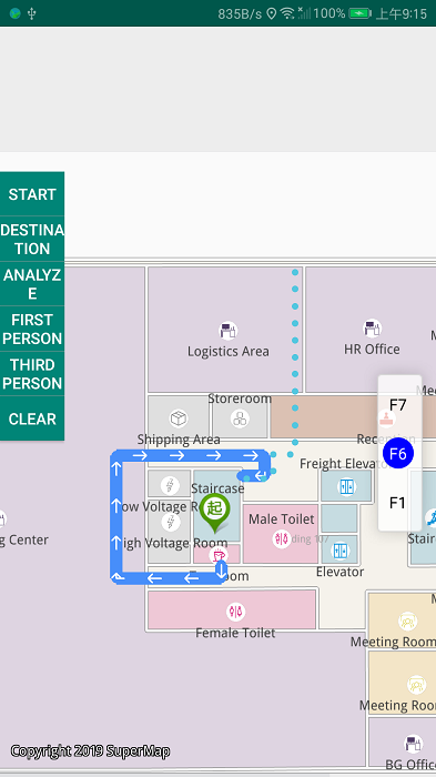
Operation effect
 |
| Figure: Indoor-outdoor Navigation Operation Effect |
Location
Android Studio
- Product package: Product package\SampleCode\SampleCode_AndroidStudio\AndroidStudioSampleCode\naviintegration
Data
Storage location
- Product package: Product package\SampleData\SupermapNaviData
Deployment Location: mobile device internal storage\SampleData\SupermapNaviData
Resource
Copy the "Product package\Resource\voice" folder to the assets folder in the project directory for navigation voice broadcasting.
License
Offline license, copy the license file to the "mobile device internal storage\SuperMap\License" folder.
Library
| jar |
|---|
| com.supermap.data.jar, com.supermap.mapping.jar, com.supermap.navigation.jar |
| so |
| libimb.so, libgnustl_shared.so, libQt5Core.so, libQt5Gui.so, libQt5Svg.so, libQt5Widgets.so(Note: Starting from version 11.1, the last five so libraries need to be added.) |
Key types/members
| Control/Class | Method |
|---|---|
| TopologyProcessing | clean() |
| NetworkBuilder | buildNetwork() |
| Navigation2 | setNetWorkDataset() , loadModel(), setStartPoint(), setDestinationPoint(), isGuiding(), cleanPath(), startGuide(), routeAnalyst() |
| NavigationEx | setStartPoint(), setDestinationPoint(), isGuiding(), cleanPath(), startGuide(), routeAnalyst() |
| mFloorListView | setCurrentFloorId() |
Basic steps
- Incremental road network:
- Click on Edit Road Network to enable the feature free hand drawing. And then you can draw a road using your hand.
- Click on Submit to submit line objects.
- Click on Generate to generate a group of incremental road network automatically.
- Indoor and outdoor navigation
- Swipe right and click on Indoor-outdoor Navigation to open the navigating page
- Click on Start(indoor). And then long press the point you want to as the starting point.
- Click on Destination(outdoor). And then long press another point you want to as the destination.
- Click on Analyze to perform the path anlaysis and display the navigation path.
- After the successful path analysis, if you click on the First Person, you will be navigated in First Person and the navigation path will be shown on your map.
- After the successful path analysis, if you click on the Third Person, you will be navigated in Third Person and the navigation path will be shown on your map.
- Click on the button Stop to stop your navigation.
- Click on the Clear button to clear all navigation paths.


