


SuperMap GIS includes cloud GIS, online GIS , PC-side GIS, Web GIS, and mobile-side GIS to fully embrace spatial big data.
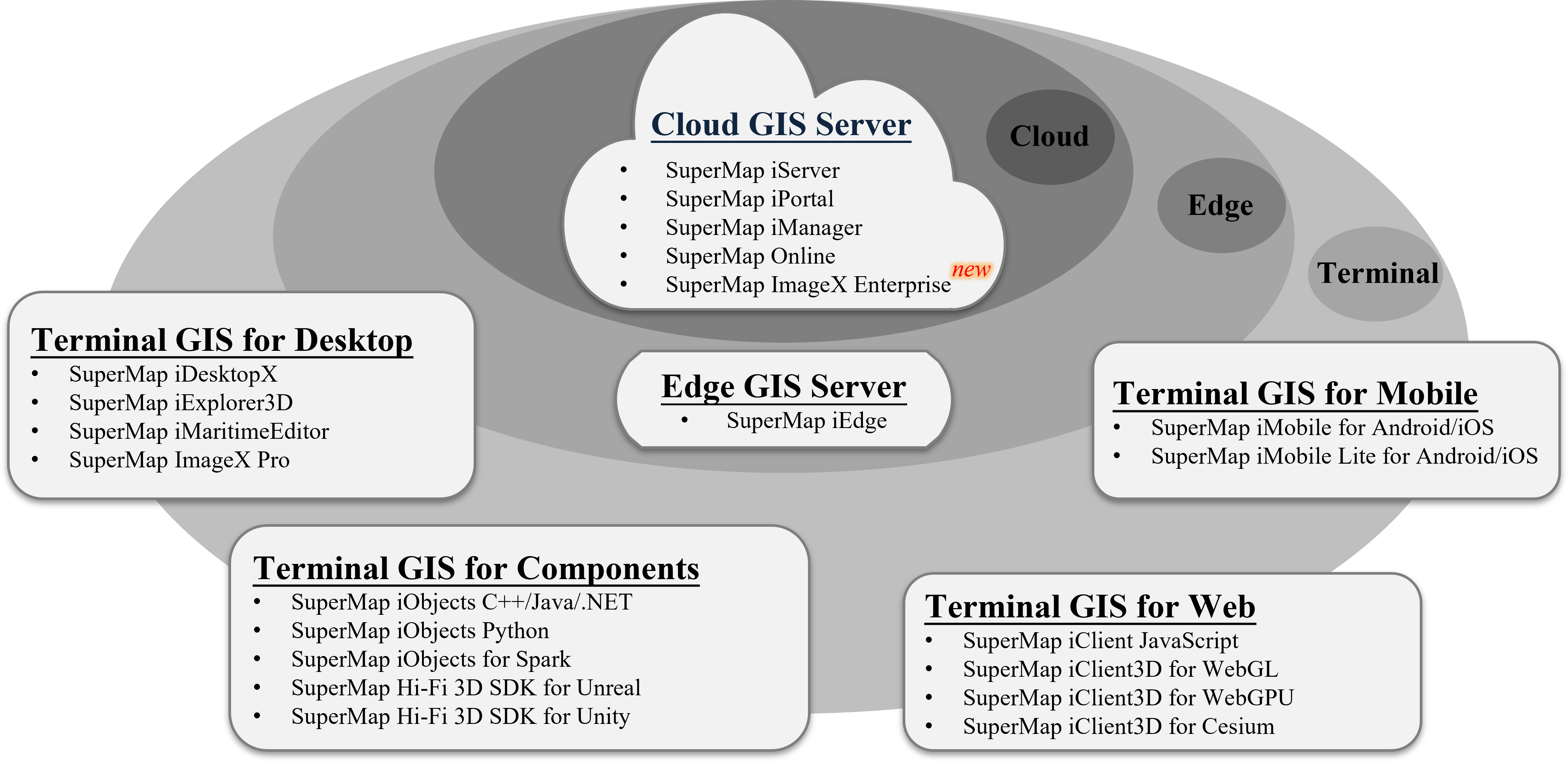 |
| Figure:SuperMap GIS product system |
Cloud GIS Server
SuperMap iServer
Cloud GIS application server based on high-performance cross-platform GIS core. It has abilities to manage, cluster and publish 2D&3D integration services and multi-level extended development capabilities.
SuperMap iPortal
A GIS portal software platform integrating GIS resource integration, search, sharing and management, with the ability of zero-code rapid website construction, multi-source heterogeneous service registration, multi-source service permission control, etc.
provides rich web-side applications, which can carry out thematic map production, spatial element editing, distributed spatial analysis, three-dimensional visualization, three-dimensional modeling, spatial data processing and analysis automation, industry large screen creation and display and other operations.
As the user center, resource center and application center of the cloud edge integrated GIS platform, you can quickly build a GIS portal site.
SuperMap iManager
A comprehensive GIS operation and maintenance management software platform can be used for application service management, infrastructure management and big data management. It provides a cloud-native GIS solution based on Kubernetes, which can create and operate cloud-native big data, AI and 3D GIS systems with one click, and achieve fine-grained dynamic scaling and flexible deployment.
It can monitor multiple GIS data storage, computing and service nodes or other web sites, monitor hardware resource occupancy, map access hotspots, node health status and other indicators, and realize the integrated operation and maintenance management of the GIS system.
SuperMap Online
Supermap online GIS platform integrates GIS data management, service management, data mining and display. Help public cloud users realize the security of GIS data on the cloud, provide rich tools to analyze and display data online, and create from creation to revenue. GIS resource creator platform. At the same time, it provides developers with a variety of SDKs to access and use GIS data to help develop business systems quickly.
SuperMap ImageX Enterprise
Remote sensing image processing server software based on Web architecture, for optical remote sensing satellite image data, integrating the world's leading photogrammetry core algorithms, based on automation, intelligence, distributed and other technologies, with large-scale DOM data product production capacity, and image intelligent interpretation ability.
Edge GIS server
SuperMap iEdge
It is deployed close to client sides or datasources and achieves near-service publishing and real-time analysis calculations thereby reduces response latency and bandwidth consumption and then relieves stress of cloud GIS center.
It can be taken as the edge node between the GIS cloud side and the application side to improve the GIS-end access experience with the proxy service aggregation and cache acceleration technology, and provides content distribution and edge analysis and computing capabilities to help build a more efficient and intelligent "Cloud-Edge-End" GIS application system.
Terminal GIS for Desktop
SuperMap iDesktopX
Cross-platform two-dimensional integrated desktop GIS software platform, supports Linux, Windows and other mainstream operating systems, natively supports the national production software and hardware environment, provides spatial data production and processing, distributed data management and analysis, map mapping, data migration, processing automation, machine learning, image processing, video map, knowledge map and other functions, which can be used for data production, processing, analysis and business system customization.
SuperMap iExplorer3D
A three-dimensional scene browsing software developed based on UE5 and SuperMap Hi-Fi 3D SDK for Unreal supports access to online/offline massive multi-source heterogeneous spatial data, supports high-fidelity rendering of three-dimensional geographical scenes, and provides support for digital twins, smart cities and other application fields.
SuperMap iMaritimeEditor
Cross-platform electronic chart production desktop software, providing S57 standard chart data management, S52 chart display, S58 data inspection, and standard extension and other functions to ensure the production of electronic chart data, support Linux, Windows and other mainstream operating systems, and meet the production needs of Xinchuang environment electronic chart production.
SuperMap ImageX Pro
Cross-platform remote sensing image processing desktop software, facing satellite remote sensing image data, integrating the world's leading photogrammetry core algorithms, based on automation, intelligence, cross-platform and other technologies, providing functions such as generating connection points, generating ground control points, regional network deviation, image registration, generating orthophoto images, image fusion, image uniform color, generating mosaic lines, dense matching, DSM filtering, etc., and has the production capacity of DOM and DSM/DEM data products.
Terminal GIS for Components
SuperMap iObjects C++/Java/.NET
SuperMap iObjects Python
SuperMap iObjects for Spark
SuperMap Hi-Fi 3D SDKs for Unreal
A programmable, scalable and customizable development platform based on the deep integration of the new generation of 3D GIS technology and Unreal Engine4/Unreal Engine5, supports local/online browsing of massive GIS space data, calculation, cropping and 3D space. Analysis, three-dimensional space query and other functions provide high-realistic three-dimensional effects and new application experience, and support the rapid customized development of digital twin, smart city and other industry application systems.
SuperMap Hi-Fi 3D SDKs for Unity
A programmable, scalable and customizable development platform based on the deep integration of the new generation of 3D GIS technology and Unity, it supports local/online browsing of massive GIS space data, supports quantitative calculation, tailoring, 3D space analysis, 3D space query and other functions, providing a high-realistic three-dimensional effect. And a brand-new application experience, supporting the rapid customized development of application systems in digital twins, smart cities and other industries.
Terminal GIS for Web
SuperMap iClient JavaScript
GIS network client development platform, based on modern Web technology stack, is a unified JavaScript client of SuperMap GIS and online GIS platform series products.
SuperMap iClient3D for WebGL
Based on WebGL technology, the 3D GIS network client development platform can be used to build plug-in-free, cross-operating system, cross-device and cross-browser 3D GIS applications.
SuperMap iClient3D for WebGPU
The 3D GIS network client development platform based on WebGPU technology can be used to build plug-in-free, cross-operating system, cross-device and cross-browser 3D GIS applications.
SuperMap iClient3D for Cesium
A 3D GIS network client development platform based on WebGL technology and CesiumJS open source framework can be used to build plug-in-free, cross-operating system, cross-device and cross-browser 3D GIS applications.
Terminal GIS for Web
SuperMap iMobile for Android/iOS
A professional fully-featured mobile GIS SDK. It not only supports 2/3D application development, and online/offline applications, but also provides multiple data visualization effects.
SuperMap iMobile Lite for Android/iOS
A lightweight mobile GIS development package for online applications, providing open source Andriod/iOS API. It has the characteristics of multi-source online base map access, diverse map visualization effects, professional GIS data collection, and online analysis services.