Tutorial
GIS Site
SuperMap iManager supports to ‘one-click’ creating GIS Site environment, the environment includes SuperMap iServer, SuperMap iPortal, and other related services. GIS Site integrates SuperMap iServer and SuperMap iPortal, both of the servers share with the same database and users center, to achieve the purpose of monitoring and managing unified.(Please refer to SuperMap iServer/iPortal Documentation for more functions introduction).
For monitoring and managing, users can understand the associations between the services by topological diagram, check the account of the site, monitoring the service trace and service metrics, and search the services by keyworkds; users can also redeploy the services, adjust the specs of service, modify the images of service, expose/hide the services address, manual/automatic scaling the services, view the log of the services, and control the command pad of containers.
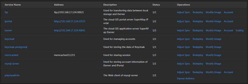
The main services in the GIS Site environment are listed below:
- iServer: The cloud GIS application server SuperMap iServer, has the abilities of publishing 2D/3D services, managing, aggregation, and extention services.
- iPortal: The cloud GIS portal server SuperMap iPortal, to solve the GIS resource integration, searching, sharing, and management, has the abilities of interface customization, service register, system dashboard monitoring, etc.
- FTP: The protocol of files transfer, used for transferring data between local storage and iServer.
- Keycloak: The open source solution between applications and services about the authorization and access management, used for managing accounts, achieves to safety and unified.
- Keycloak-PostgreSQL: Used for storing the data of Keycloak.
- Memcached: The distributed memory objects caching system, used for sharing session.
- MySQL-Server: MySQL database, used for storing account information of iServer and iPortal.
- PhpMyAdmin: The management tool of MySQL database, manage MySQL by Web client.
