


Instructions for Use
The GeoSOT (Geographic Coordinate Subdividing Grid with One-Dimension Integral Coding on 2n-Tree ) is a global longitude-latitude subdivision grid based on a 2n-dimensional integer array.
With the development of the spatial information industry, spatial data content across different industries has become specialized, diverse, and interrelated. Data production and maintenance are often decentralized across various organizations, leading to different grid standards adopted by different departments and systems. While establishing independent data organization and indexing types within departments can meet their operational needs, cross-departmental data applications face significant challenges due to inconsistent data organization methods, hindering the exchange and sharing of spatial information.
The GeoSOT global longitude-latitude subdivision grid is a grid system based on the geographic coordinate system, seamlessly covering the entire world with uniform and stable grid connections. Its subdivision grids feature identifiability, hierarchy, aggregation, and relevance, enabling organic associations between levels and providing a foundation for multi-scale map representation. Using longitude-latitude division, this grid aligns well with national standard maps and facilitates conversion with mainstream data types, promoting compatibility of multi-source data and cross-department/ system spatial data integration.
The GeoSOT grid achieves integer-degree quad-tree subdivision through three spatial expansions (expanding Earth's geographic space to 512°, 1° to 64′, and 1′ to 64″). The specific subdivision methods are as follows:
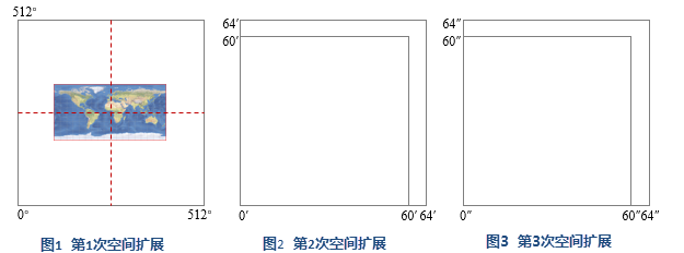
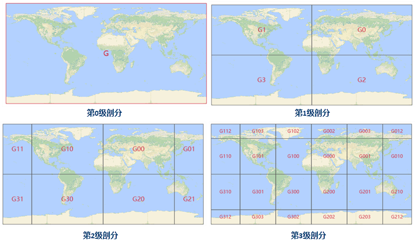
- First Expansion: Project Earth onto a plane, expanding 180°×360° to 512°×512° as the zeroth-level grid. Using the prime meridian-equator intersection as center, recursively subdivide until reaching 1° grid units (degree-level grid). This includes 10 levels (0-9).
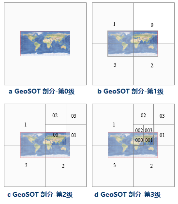
- Level 0: 512°×512° cell centered at prime meridian-equator intersection, coded as G (Globe). (Fig. a)
- Level 1: Four 256°×256° grids coded as Gd (d=0,1,2,3). G0 corresponds to northeast hemisphere. (Fig. b)
- Level 2: Four 128°×128° grids coded as Gdd. Some grids (e.g., G02, G03) lack geographical significance and remain undivided. (Fig. c)
- Level 3: Four 64°×64° grids coded as Gddd. G001 corresponds to China-India-Southeast Asia. (Fig. d)
- Lower levels follow analogous subdivision principles.
- Second Expansion: Expand 1° (60′) to 64′, recursively subdividing to 1′ units (minute-level grid, levels 10-15). Level 10 grids (32′×32′) are coded as Gddddddddd-m.
- Third Expansion: Expand 1′ (60″) to 64″, subdividing to 1″ units (second-level grid, levels 16-21). Sub-second divisions continue up to level 32. Level 16 grids (64″) are coded as Gddddddddd-mmmmmm-s.
- Levels 22-32 follow strict quartering subdivision.
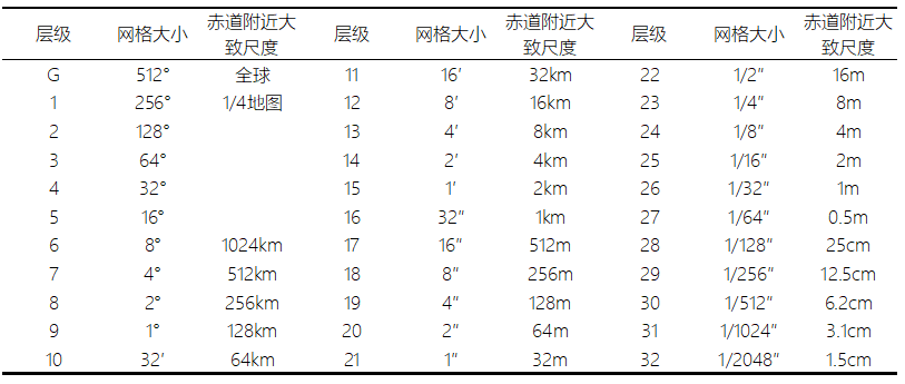
GeoSOT Grid contains 32 levels from global to centimeter scales, forming a global quad-tree system. The area ratio between adjacent levels is approximately 4:1. Table 1 shows grid counts and spatial scales at each level.
 |
| GeoSOT Partition Frame Level Features |
Grid Cell Encoding
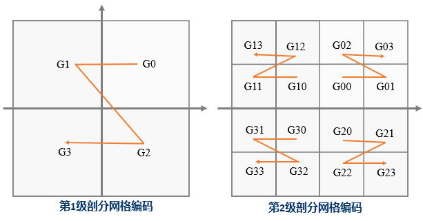
GeoSOT Grid uses 64-bit codes with 32-bit quaternary encoding: bits 1-9 (degree-level), 10-15 (minute-level), 16-21 (second-level), 22-32 (sub-second). Encoding format: "Gddddddddd-mmmmmm-ssssss.uuuuuuuuuuu" where d/m/s/u=0-3. Codes start with G, using "-" separators between degree/minute/second levels and "." for sub-second levels. Grids near prime meridian-equator intersection are coded 0, farthest as 3.
 |
| GeoSOT Grid Unit Encoding |
This encoding ensures global uniqueness and precise geographic spatial meaning for each grid unit.
Function Entrance
- Map tab -> Drawing group -> GeoSOT Grid in current workspace.
- Data tab -> Data Processing group -> Map Cartography -> GeoSOT Grid.
Parameter Description
- Start Level: Initial generation level (0 to End Level). Default: 0.
- End Level: Final generation level (Start Level to 32). Allows single-level generation.
- Range Type: Supports geographic coordinate system ranges. Options: Global, National Area, User-defined. Custom bounds can be set via coordinates or function buttons:
- Whole Map: Current map's full extent (viewable via Map Properties).
- Current Window: Current map view range (adjustable via zoom/scale).
- Copy: Copy bounds to clipboard.
- Paste: Paste bounds from clipboard.
After parameter setup, generated grids are added to a new map by default.
Application Example
Generating levels 0-3 Global Grid for "World_Google" map (SuperMap SampleData -> World Workspace). Four grid levels are created with code attributes. Edge grids beyond geographical areas (e.g., G11, G112) are clipped automatically.
 |
| GeoSOT Grid Results |