


In order to meet the needs of various engineering design and construction, most of the large-scale topographic maps are divided at equal intervals according to the vertical and horizontal coordinate grid lines, that is, the square division and numbering method is adopted. General provisions:
- The scale of 1:5000 shall be 40cm in length and 40cm in width, i.e. 2km on the ground.
- The scale of 1:2000, 1:1000 and 1:500 shall be divided into 50cm in length and 50cm in width.
- If the survey area is a long and narrow strip, in order to reduce the number of drawing boards and drawings, arbitrary framing can be used.
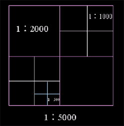 |
| Figure: Rectangular Tile |
The coordinate numbering method is generally adopted for the numbering of map sheets. The ordinate X and abscissa y of the southwest corner of the map sheet constitute the number. The coordinate value of 1:5000 is taken to km, 1:2000 and 1:1000 to 0.1 km, and 1:500 to 0.01 km. For example, if the coordinates of the southwest corner of a 1:1000 topographic map are X = 6230 km and y = 10 km, then its number is 6230.0-10.0
The basic map numbering method can also be used, that is, based on the 1:5000 topographic map, the numbering of Map with Large Scale is to add Roman numerals after its number. For example, if the number of a 1:5000 topographic map is 20-60, the numbers of other maps are as shown in the figure below:
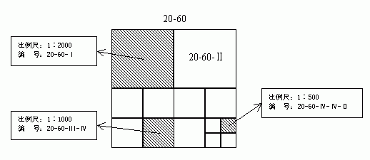 |
| Drawing: 1:5000 basic drawing number method sheet numbering |