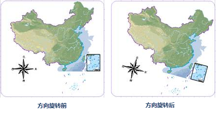
A complete map is usually composed of map, compass, scale, legend, title and other map elements. After adding, typesetting and organizing various map elements in the layout, and setting the attributes, size and position of each element, it can be output as a map.
Map
The main element of the layout is Map, and other elements are arranged around Map. Map added in Layout can be rectangle, Rounded Rectangle, polygon, circle, ellipse, etc. Multiple maps can be added to one layout, and different associated maps can be displayed in one layout. At the same time, the map can also be set. In Layout, one Map can only be associated with the map in one Map. However, multiple maps can be drawn in one Layout, and the different associated maps can be displayed in the Layout. At the same time, the map placement position, size, attribute, border, etc. Can also be adjusted.
The North Arrow
The compass is used to indicate the direction of the map. The compass is linked with the map Rotation angle. When the map angle changes, the direction of the compass will also rotate and change. On the contrary, when the direction of the compass changes, the direction of the map will also change.

Scale
Map is a reduced representation of useful information in space according to a certain proportion through cartographic generalization by using symbol system according to certain mathematical rules. The scale refers to the degree to which geographic information is reduced, that is, the ratio of the length of the line segment on the map to the horizontal length of the corresponding line segment on the ground. The selection of map content, the degree of generalization and the accuracy of data are closely related to the scale.
The scale object is also displayed in association with the Map, and the scale of the scale changes with the enlargement and reduction of the map.
Legend
Maps use various symbols, different colors and labels to represent spatial geographic information. For example, roads are drawn with lines of different colors, widths and patterns to represent roads of different types and levels. Land Use types are represented by different surface fills, for example, water bodies are represented by blue; Use special symbols to represent special features, such as subway stations and airports; use Text Annotation to represent streets and buildings. The legend is a description of all the map symbols used on the map.
 |
| Figure 3: Example of legend |
Map title
The map title is mainly used to describe the main content of the map. The map title can be directly added in the layout. The Text Style can be set as the normal text art Font style, and it can be set as Label Alongline, which is convenient for users to make more beautiful maps.
 |
| Figure 4: Map title |


