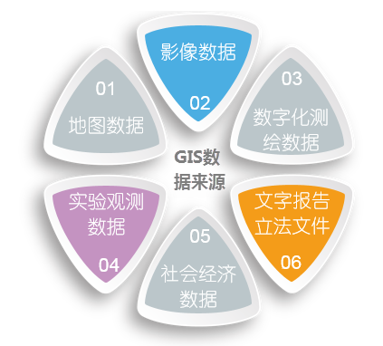
The data source of GIS refers to the source of all kinds of data needed for the establishment of geographic database, mainly including maps, remote sensing images, text data, statistical data, measured data, multimedia data, existing system data, etc. There are many data sources and Data Types in GIS, which can be summarized as follows:
- Map data
Map is the traditional description form of geographic data, which is a two-dimensional plane representation of points, lines and surfaces with a common reference Coordinate System. It is rich in content, the spatial relationship between entities on the map is intuitive, and the categories or attributes of entities can be identified and represented by various symbols. Map is an important Datasource of GIS. These maps are rich in content, the spatial relationship between entities on the map is intuitive, the category or attribute of entities is clear, and the measured topographic map has high accuracy, which is the main carrier of geographic information and the most important information source of geographic information system. Most of the GIS systems in our country get their graphic data from maps.
- Image Data
It is mainly derived from satellite remote sensing and aerial remote sensing, including multi-platform, multi-level, multi-sensor, multi-temporal, multi-spectral, multi-angle and multi-resolution remote sensing Image Data. Satellite remote sensing data can provide Spatial Info of the same time phase, the same band, the same scale and the same accuracy in a wide area in time, and aerial remote sensing can quickly obtain detailed information in a small area. As a powerful means of acquiring and updating Spatial Data, remote sensing can provide a variety of resources and environmental data for GIS in a timely, accurate, comprehensive and large-scale manner. The dynamic characteristics of remote sensing are very beneficial to the multi-temporal updating of GIS database. It is particularly important to obtain remote sensing information in solving a wide range of statistics-based geographic information systems.
- Digitized mapping data
With the updating of surveying and mapping instruments and the development of surveying and mapping technology and computer technology, the traditional surveying and mapping technology is gradually replaced by digital surveying and mapping technology. Vector Data can be directly obtained by various new surveying and mapping technologies, mainly including GPS positioning data, total station field measured data, full digital photogrammetry data, etc. These data can form the Digital Map of high precision terrain, cadastre and other special topics, which is a very accurate and current information of GIS.
- Experimental observation data
With the production of various thematic maps and the establishment of various GIS systems, it is more and more possible to obtain digital graphic data and attribute data directly. Digital data has also become an indispensable part of GIS information sources. However, the adoption of digital data needs to pay attention to the conversion of data format and the accuracy and reliability of data.
- Socio-economic data Outputting the results of
user query or data analysis in an appropriate form is the last process of GIS problem solving process. Output format is usually of two types: display on a computer screen or output via plotter. The technology in this aspect mainly includes: editing, graphic decoration, symbol making, picture legend generation, publishing and printing, etc.
- Various written reports and legislative documents
Various written reports and legislative documents are widely used in some management GIS systems. For example, in the urban planning management information system, various urban management regulations and planning reports play an important role in planning management.


