


Oblique Photography (oblique image) refers to the image obtained by an aerial camera with a certain inclination angle. Oblique Photography is a new technology developed in the field of international surveying and mapping remote sensing in recent years, which overturns the limitation that orthophoto can only be shot from a vertical angle in the past. By carrying multiple sensors on the same flight platform and collecting images from five different angles, such as one vertical and four inclined angles, more complete information of ground objects can be obtained.
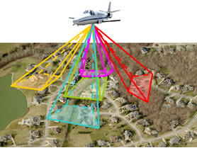 |
| Photo: Oblique Photography |
Oblique Photography technology has the following four features:
- Reflect the real situation around the surface features: it can obtain images of multiple viewpoints and angles of view, so as to obtain more detailed side information, with higher resolution and larger field of view, and the phenomenon of surface features occlusion is more prominent.
- Oblique Photography can realize single image measurement: through the application of supporting software, it can measure the height, length, area, angle and slope based on the result image, which expands the application of Oblique Photography technology in the industry.
- Improve the efficiency of urban 3D modeling: For various applications of 3D digital cities, the cost of 3D modeling can be effectively reduced by using the characteristics of large-scale mapping of aerial photography and the way of extracting and pasting textures from Oblique Photography images.
- Small amount of data and easy to publish on the network: Compared with the huge amount of 3D Data used in the three-dimensional GIS technology, the amount of data of the image obtained by using the Oblique Photography technology is much smaller, and the data format of the image can be quickly published on the network by using the mature technology to realize the sharing application.
Application of Oblique Photography:
The aerial oblique image can not only reflect the real situation of ground objects, but also greatly expand the application of Remote Sensing Imagery by using advanced positioning technology, embedding accurate geographic information, richer image information and more advanced user experience. This technology can be widely used in emergency command, homeland security, urban management, real estate tax and other fields.