


Feature Description
The stream system is the first step in extracting hydrological networks. Subsequent processes including stream order, stream link, and stream to feature are all based on raster river system operations.
Valleys can be identified by cells with higher cumulative flow accumulation values. By setting a threshold for water catchment volume, cells exceeding this threshold in cumulative flow accumulation are extracted to generate a raster river system. In practice, this threshold may vary for valleys of different levels or same-level valleys in different regions. Therefore, determining the appropriate threshold requires consideration of actual terrain features in the study area and iterative experimentation.
As previously described, raster river systems can be extracted through algebraic operations on cumulative flow accumulation grids. For instance, if research determines areas with cumulative flow accumulation exceeding 2000 as catchment zones in a specific region, the stream system expression would be:
[datasource.cumulative flow accumulation raster] > 2000
The calculation produces a binary raster river system where cells with cumulative flow accumulation above 2000 are assigned value 1, while others receive 0. The value 0 represents NoValue.
The following illustration shows an extracted raster river system:
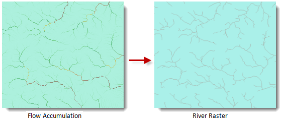 |
| Figure: Raster river system extraction result |
Feature Entry
- Spatial Analysis Tab -> Raster Analysis Group -> Hydrology -> Stream System.
- Toolbox -> Raster Analysis -> Hydrology -> Stream System.
Parameter Description
- Flow Accumulation Data: Select the datasource and dataset containing the cumulative flow accumulation raster.
- Threshold: Input the cumulative flow accumulation threshold for extraction.
- Pixel Format: Eight pixel formats are available: 1-bit, 4-bit, single-byte, double-byte, integer, long integer, single, and double. For detailed specifications, refer to raster dataset pixel format.
- Ignore NoValue Cells: When checked, NoValue cells in input raster datasets will be excluded from algebraic operations, retaining NoValue (typically -9999) in corresponding result dataset cells. When unchecked, application will process NoValue cells as regular values, potentially altering minimum/maximum values in result raster. Default: checked.
- Compress Dataset: When checked, the application will store the result dataset with compression. Default: unchecked.
- Result Data: Specify the target datasource and dataset name for result storage.
- Click Execute to run the analysis. Upon completion, the output window will display success or failure status.