


Hydrology
Water is closely related to human life. Studying its origin, distribution, existence, and movement patterns holds significant importance. Hydrology builds a river network model based on the Digital Elevation Model (DEM) to study watershed hydrological characteristics, simulate surface hydrological processes, and estimate future surface hydrological conditions. It helps analyze flood extent, locate surface runoff pollution sources, predict impacts of terrain changes on runoff, and is widely applied in regional planning, agriculture/forestry, disaster prediction, road design, and other fields.
Basic Concepts
Understanding watershed-related concepts is essential for properly applying hydrological analysis based on DEM raster data. The following diagram helps illustrate key concepts.
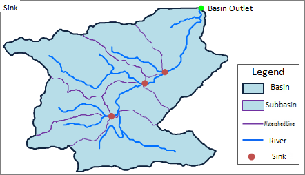 |
| Figure: Watershed schematic diagram |
River: A network system formed by water bodies sharing the same drainage destination within a watershed, including rivers, lakes, marshes, and reservoirs.
Watershed: The land area that contributes water to a river system, also known as a drainage basin or catchment area.
Subbasin: A river system consists of multiple stream segments, each having its own contributing area called a subbasin. Larger watersheds can be further divided into subbasins.
Watershed divide: An irregular curve connecting the highest points between adjacent watersheds. Water on either side flows into different basins. Typically formed by ridges or highlands, but can also occur in gently sloping plains or lakes.
Pour Point: The outlet where water drains from a watershed, usually the lowest point on the watershed boundary.