


Feature Description
Updates the attribute information of objects in the target dataset based on specified spatial relationships. The Attribute Update functionality provides two modes for selecting and updating the target dataset: The first mode updates the entire dataset; the second mode updates based on a filter expression.
Function Entry
- Data Tab->Data Processing->Vector->Attribute Update.
- Toolbox->Data Processing->Vector->Attribute Update.
Parameter Description
- Data with Attributes Offered: Select the source and dataset providing the attributes. If a dataset is selected in the Workspace Manager, it will be set as the Data with Attributes Offered by default.
- Target Dataset: Set the target dataset to receive the new attributes and its associated data source.
- Statistic Field: Select a field to store the count of updated sub-objects. Sub-objects that are not updated are assigned a value of 0, while updated sub-objects are numbered sequentially as 1, 2, 3...
- Filter Expression: Click the button on the right to open the SQL Expression dialog box to set the filter expression. During the attribute update, the selected fields from the source dataset will be updated to the object properties in the target dataset that meet the expression criteria.
- Spatial Relationships: Spatial relationships refer to the spatial relationships between the geometry providing the attribute and the target geometry. Target geometries that satisfy the specified spatial relationship will be assigned attributes. Four relationships are provided: Contain, Within, Intersect, and Nearest. The spatial relationships are described as follows:
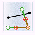
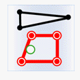
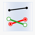
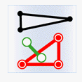
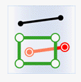
In the following diagrams, green indicates objects from the dataset providing attributes, red indicates targets that satisfy the spatial relationship, and black indicates targets that do not satisfy the spatial relationship.
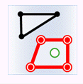
- Contain: The geometry from the dataset providing attributes contains the geometry from the target dataset.
Object Target Point Target Line Target Region Attribute Point 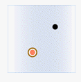
Attribute Line 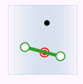
Attribute Region 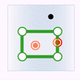
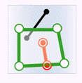
- Within: The geometry from the dataset providing attributes is contained within the geometry from the target dataset.
Object Target Point Target Line Target Region Attribute Point 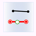
Attribute Line 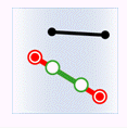
Attribute Region 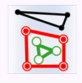
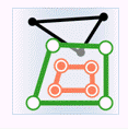
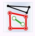
- Intersect: The geometry from the dataset providing attributes intersects with the geometry from the target dataset.
Object Target Point Target Line Target Region Attribute Point 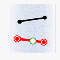
Attribute Line 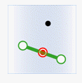
Attribute Region 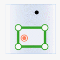
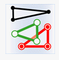
- Nearest: Calculates the object(s) with the closest distance between objects in the dataset providing attributes and the target dataset. There can be multiple objects with the closest distance.
- Search Radius: Used to set the maximum distance for searching for the nearest object. If a positive value is set, then matching occurs only when the closest distance does not exceed this value. If set to 0 or left blank, it means only matching objects with coincident geometric positions, such as points within regions or points on lines. If set to a negative value, it means there is no limit on the search distance, and the nearest object is always matched.
Thirteen units are provided: Millimeter, Centimeter, Decimeter, Meter, Kilometer, Inch, Foot, Mile, Yard, Nautical Mile, Degree, Minute, and Second. It is recommended to keep this consistent with the dataset's unit.
- Distance Field: Specifies the field in the target dataset used to store the measured distance result to the nearest object. You can directly select an existing field from the source data via the dropdown option as the distance field. A field value of -1 indicates that the nearest geometry was not found within the specified search radius. If this parameter is not filled in, a distance field will not be generated.
 Notes:
- If an existing field is selected as the distance field, the selected field must be of Double type.
- If the specified field does not exist in the source dataset, the system will automatically create this field and save the results into it.
- Search Radius: Used to set the maximum distance for searching for the nearest object. If a positive value is set, then matching occurs only when the closest distance does not exceed this value. If set to 0 or left blank, it means only matching objects with coincident geometric positions, such as points within regions or points on lines. If set to a negative value, it means there is no limit on the search distance, and the nearest object is always matched.
- Contain: The geometry from the dataset providing attributes contains the geometry from the target dataset.
- Boundary Handling: Used to determine whether the boundary of a region object is considered to be inside the region when judging spatial relationships. It can be set to Not Contain Border or Contain Border. This combo box is only activated when it's necessary to determine the containment relationship between a region and a point, or the intersection relationship between a region and a line.
- Contain Border: Indicates that points located on the region's border belong to the points contained by the region. When a point on a line coincides with a point on the region's border, it indicates that the region intersects with the line.
- Not Contain Border: Indicates that points located on the region's border are not considered points contained by the region. If points on a line only coincide with points on the region's border but are not inside the region, they are not considered to intersect.
- Value Taking Mode: If there are multiple objects that meet the conditions and can provide attribute data, the attribute objects will be processed according to a specified value-taking mode before being assigned to the target.
- Assign Value: Randomly takes the attribute data from one of the objects for updating. This mode is suitable for one-to-one assignment.
- Average: Takes the average value for updating. Valid for fields of numeric type.
- Sum: Takes the sum of the attribute values from all objects for updating. Valid for fields of numeric type.
- Maximum: Takes the maximum value from among the object properties for updating. Valid for fields of numeric type.
- Minimum: Takes the minimum value from among the object properties for updating. Valid for fields of numeric type.
- Max SMID: Takes the object property value from the object with the largest SmID for updating.
- Min SMID: Takes the object property value from the object with the smallest SmID for updating.
- Concatenate: Uses a connector to merge multiple attribute values and update them into a single attribute value of the target. Mainly used when multiple attribute values need to be updated into the same field at once, such as counting the multiple administrative regions a river flows through. When using this mode, the target field type must be Text or Character type.
- Maximum Intersection Area: If multiple intersecting sub-objects exist in space, takes the object property value from the one with the largest intersection area for updating.
- Connector: When the Value Taking Mode is set to Concatenate, you need to set the connector parameter, which is used to separate multiple attribute values. The default value is a comma.
- Field Settings: In the list, check the Provide Attribute Fields you want to use for the data update. Then, click on the corresponding Target Field cell to select and set the target field to which the attribute will be updated.
Notes:
Supports storing update results across data types, reducing the need for secondary processing by users. It also supports creating new target fields for attribute update.
- After the update is complete, the corresponding field values from the source dataset will be updated into the fields (either newly created or existing) in the attribute table of the target dataset.
Notes:- The coordinate systems of the dataset providing attributes and the target dataset must be consistent; otherwise, the update may fail.
- The default length for Character type fields is 1. If the target field type is Character, you need to modify the field length to an appropriate value before updating, otherwise the update may fail.
- The Provide Attribute Fields and Target Fields must correspond one-to-one. If the data types do not match, a forced conversion will be attempted during the update. If the conversion fails, the update for that target field will be abandoned.
- Different statistical methods correspond to different Statistic Fields. When using the Average, Sum, Maximum, or Minimum Value Taking Modes, the source field type must be numeric.
Related Topics