


Feature Description
A cell is the fundamental information unit in grid/image data. Its coordinate position is determined by row and column numbers. Each cell possesses an attribute value representing information at its corresponding location. For example, a DEM raster cell reflects elevation information at that position. Cell size, also known as spatial resolution, refers to the ground area represented by a single cell.
For grid/image data with fixed spatial resolution, resampling can modify cell size.
The text box to the right of "Pixel" in the "Grid/Image Parameters" group allows setting the resampled pixel size.
Steps
- In the "Register" tab's "Grid/Image Parameters" group, enter the resampled pixel size in the text box to the right of the "px" label. The unit corresponds to the projected coordinate system of the registration layer.
- Perform registration on the raster/image dataset. By examining attributes of the saved registered result dataset, you'll observe changes in X and Y resolution values.
Taking bilinear interpolation as an example, this demonstration resamples a raster with original pixel size 0.00027 in geographic coordinate system to 0.013. Below shows the registration effect.
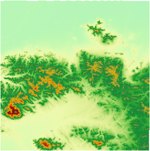 |
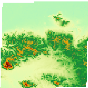 |
| Before Resampling | After Resampling |
 Notes
Notes
- The pixel size unit matches the projected coordinate system's unit. For layers in projected coordinate systems, units could be meters/kilometers/feet. For geographic coordinate systems, units are degrees/minutes/seconds.
- Select appropriate pixel size for resampling. Excessively large values cause information loss, while overly small values defeat resampling purposes.