


Draw Point Object
Function Description
In GIS applications, we often use point objects to describe point features such as elevation control points, mines, caves, etc. Buttons for drawing point objects are organized in the Object Drawing group on the Edit Data tab, and you can draw a point when the current editable layer is a point layer or a CAD layer.
Function Entry
- Edit Data tab -> Object Drawing group -> Point.
Operation Instructions
- In the Edit Data tab, in the Object Drawing group, click the Point button to enter the drawing state.
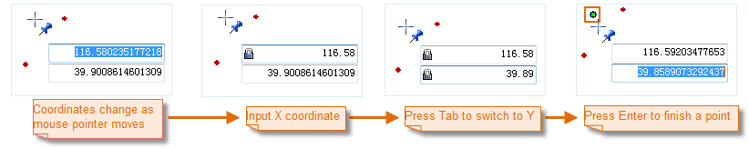
- After turning on the Parametric Drawing function, move the mouse to the map. As the mouse moves, two parameter input boxes appear to display and set the coordinate values of the current mouse position. Enter X and Y coordinate values in the input boxes as the position of the point object to be drawn. Press Enter to confirm the drawing. The drawn point object will be displayed on the map.
 Note:
Note:When the user edits the values in the parameter input boxes, the input boxes will be locked, meaning the values in the parameter input boxes will not change with mouse movement and only display the user-entered values. Press Tab to switch focus between the X and Y coordinate input boxes, i.e., edit state. Press and hold Esc to cancel the locked state of the current parameter input boxes.
- Repeat the previous step to draw multiple point objects.
- After drawing is complete, right-click or click the drawn point object again to end the drawing.