


Feature Description
The Spatial Index button is used to manage the spatial index of the selected dataset in the current Workspace Manager, including viewing the spatial index information of the dataset and creating a spatial index for the dataset.
Function Entry
- Start Tab -> Data Processing -> Spatial Index.
Operation Steps
- In the Workspace Manager, select the dataset for which you want to view spatial index information or create a spatial index. You can select multiple datasets simultaneously by holding the Shift or Ctrl key.
- In the Data Processing group of the Start tab, click the Spatial Index button to open the Manage Spatial Index dialog box. As shown in the figure below, each record in the dialog corresponds to the information of one dataset.
The "Original Index" field displays the index type of all selected datasets. If you want to rebuild the spatial index for a dataset, you can select the index type to be rebuilt for the corresponding dataset in the Index Type column.
For the usage and description of the "Spatial Index Manager" dialog box, refer to the introduction of the Spatial Index Manager dialog box below.
- If you want to rebuild the spatial index for a dataset, set the index type to be rebuilt for the corresponding dataset in the Index Type column, and then click the OK button in the dialog box. The application will rebuild the spatial index for all datasets in the dialog box based on the values in the Index Type column. Therefore, before creating a spatial index, you should remove the records of datasets that do not need to rebuild the spatial index from the dialog box.
- After viewing or creating the spatial index for the dataset, click the Cancel button in the dialog box to exit the Spatial Index Manager dialog box.
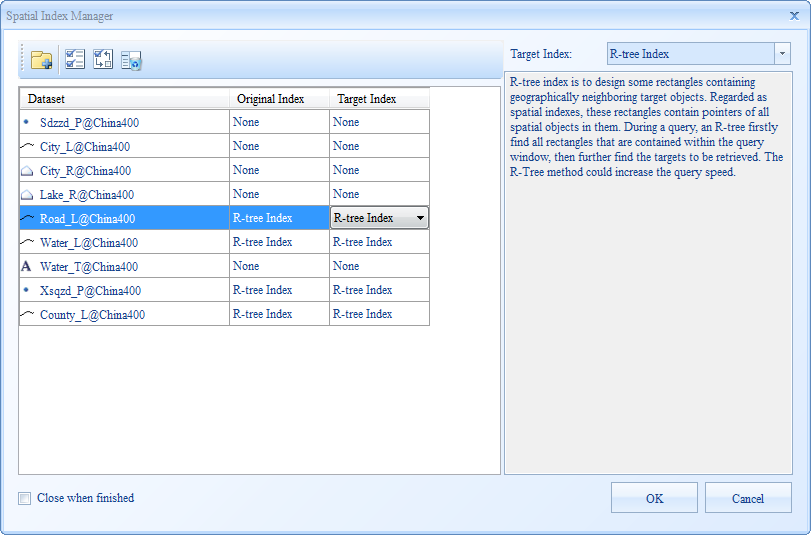 |
| Figure: "Spatial Index Manager" Dialog Box |
Parameter Description
Toolbar Button Description
- Add: Click the Add button to open the Select dialog box. Through this dialog, you can add the spatial index information of other datasets to the "Spatial Index Manager" dialog box for display and further operations. After selecting the datasets in the Select dialog box, click the OK button to complete the addition.
- Select All: Used to select all records in the table on the left side of the Spatial Index Manager dialog box.
- Select Reverse: Used to invert the selection of records in the table on the left side of the Spatial Index Manager dialog box. That is, records that were not selected become selected, and selected records become unselected.
- Remove: Used to remove one or more selected records from the table on the left side of the Spatial Index Manager dialog box.
Spatial Index Manager Dialog Box
The left area of the Spatial Index Manager dialog box displays the information of all currently selected vector datasets in the Workspace Manager in tabular form, mainly showing the index type information of the datasets. Each record in the table corresponds to the information of one dataset. The following details the information represented by each column in the table and the function and usage of other items in the dialog box.
- Dataset Column: Displays the specific type, alias, and the name of the data source where the vector dataset is located.
- Datasource Column: Displays the data source to which the vector dataset belongs.
- Original Index Column: Displays the current index type of the vector dataset.
- Index Type Column: If you want to rebuild the spatial index for the dataset, you can specify the index type to be rebuilt in this column. The default value of this item is equal to the "Original Index" value of the dataset. When the application rebuilds the spatial index for the dataset, it will rebuild the specified type of spatial index for the corresponding dataset based on the value in the "Index Type" column.
Click to select a cell in the "Index Type" column, and click again. A drop-down button will appear on the right side of the cell. Click the drop-down button to open a drop-down menu. The menu lists the index types supported by the corresponding vector dataset. The user can select any one of these types as the rebuild spatial index type for the corresponding dataset.
- In the right area of the Spatial Index Manager dialog box, the Index Type combo box is bound to the value of the "Index Type" item of a selected record in the left table, meaning they change synchronously. If there is no selected record or multiple selected records in the left table, the Index Type combo box will not display any content.
Below the Index Type combo box, the description of the index type currently displayed in the "Index Type" combo box will be shown.
Parameters
Mapsheet Index: Click the drop-down button on the right of Index Type and select Mapsheet Index. This type of index requires setting the Field Index or Spatial Index parameters. The details are as follows:
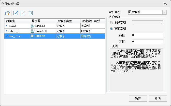 |
| Figure: Create Mapsheet Index |
- Field Index: Indicates classifying the spatial objects in the dataset based on the field value of a specified field to create a mapsheet index.
- Spatial Index: Indicates dividing the dataset into multiple cells based on the specified width and height, and then building an index on this basis. The units of the width and height of the range are consistent with the units of the dataset.
Dynamic Index: Click the drop-down button on the right of Index Type and select Dynamic Index. This type of index requires setting the Field Index or Spatial Index parameters. The details are as follows:
- Base Point: Sets the center point of the grid index. It is generally the center point of the dataset.
- First-Level Grid Width: Sets the size of the first-level grid of the dynamic index. This parameter cannot be 0. The unit is consistent with the unit of the dataset.
- Second-Level Grid Width: Sets the size of the second-level index grid of the dynamic index. The unit is consistent with the unit of the dataset.
- Third-Level Grid Width: Sets the size of the third-level index grid of the dynamic index. The unit is consistent with the unit of the dataset.
 Note:
Note:- Engine types that support creating dynamic index include: SQLPlus, OraclePlus, DB2, MySQL.
- Currently, R-tree index, Q-tree index, Dynamic index, and Mapsheet index are supported.
- UDB and PostgreSQL data sources only support R-tree index (RTree).
- For other database data sources, R-tree index, Q-tree index, Dynamic index, and Mapsheet index are supported.
- Dynamic index is not supported.
- Route dataset does not support Mapsheet index (TILE).
- Attribute datasets do not support any type of spatial index.
Related Topics