


Feature Description
Building spatial index for chart groups can significantly improve data query and analysis efficiency. The index reduces irrelevant information searches by quickly locating relevant data, especially during large-scale geographic data processing, which notably accelerates response speed and saves system resources.
For example, in maritime navigation applications, ship positioning systems require real-time queries of chart data in current sea areas. Spatial index helps systems rapidly find relevant information within the region, enabling fast map refresh and precise display to ensure real-time performance and accuracy of navigation systems.
The Manage Chart Group Spatial Index feature manages spatial indexes for chart groups, providing functions like viewing spatial index information of datasets within groups and creating spatial indexes for datasets.
Steps
- In Workspace Manager, right-click the target chart group needing spatial index operations, select Build Spatial Index. The Manage Chart Group Spatial Index dialog will appear, displaying information for each dataset in the feature object dataset list.
- The Target Datasource combo box shows the datasource of the selected chart group. You can switch to other datasources in the workspace to manage their chart group spatial indexes.
- Click the drop-down button beside the Chart Group combo box to select chart groups within the datasource for index management operations.
- The toolbar provides these buttons:
- Select All: Selects all records in the left table, allowing batch setting of index types.
- Select Reverse: Inverts selection in the table, turning unselected records to selected and vice versa.
- The left panel of the Manage Chart Group Spatial Index dialog displays dataset information in the current chart group, mainly showing each dataset's index type:
- Checkbox column: Check to rebuild spatial index for corresponding dataset; unchecked datasets won't be rebuilt.
- Chinese Name column: Chinese name of the chart feature object dataset.
- Object Abbreviation column: Abbreviation of the feature object.
- Original Index column: Current index type.
- Index Type column: Allows redefining index type for datasets, defaulting to original index. Clicking the cell reveals a dropdown menu listing supported index types. Refer to R-tree Index for more information.
- Selecting a cell in the Index Type column activates a dropdown menu listing supported index types for the corresponding vector dataset.
- In the right panel of the Chart Group Spatial Index Manager dialog, the Index Type combo box binds to selected records' index types in the left table. Modifying the combo box value will synchronously update selected records' index types.
Below the Index Type combo box displays descriptions of the currently selected index type. - In the right panel, the index type combo box links with the left table's index type column. Changes in the combo box value automatically update corresponding index types in selected records. The current index type description appears below the combo box.
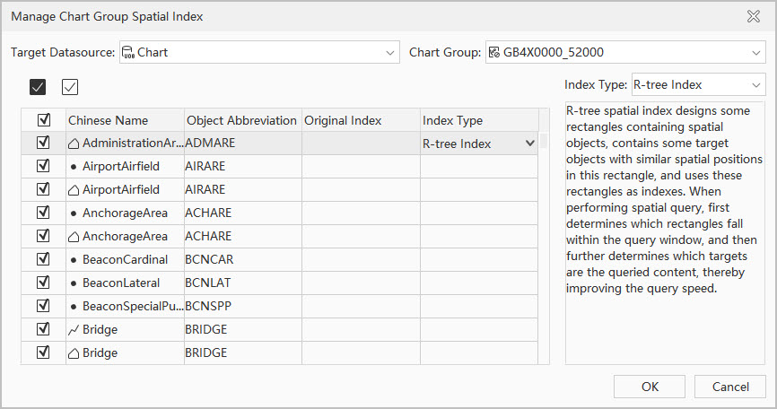 |
| Figure: Manage Chart Group Spatial Index Dialog |
 Note:
Note:The system supports R-tree Index. When database records are fewer than 1,000, creating spatial indexes may not improve query speed, and the system won't create spatial indexes.
Before creating spatial indexes, you can deselect datasets that don't require index rebuilding, only checking chart feature object datasets needing index creation.
Related Topics