


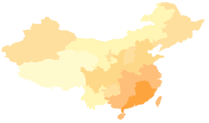
The provincial administrative region dataset Provinces_R in the China400 datasource can be used for base map configuration. To better present thematic content, we can create a national average temperature distribution map (August 2009) based on the AvgTemperature_Aug field (representing average temperatures across regions in August 2009) from Provinces_R. When placed beneath the weather forecast matrix label thematic map, it provides additional meteorological information and enriches map visualization.
Steps
- In the Layer Manager, select the layer Provinces_R;
- On the Ribbon's Thematic Map tab, choose "Graduated Color Thematic Map". The system will automatically create a default-styled graduated color thematic map based on Provinces_R. The newly created thematic map will be added to the current map window as a top-layer thematic layer, with corresponding node added in Layer Manager;
- Configure parameters in the "Graduated Color Thematic Map" dialog:
- Expression: Set segmentation expression to AVGTEMPERATURE_AUG in the combo box next to "Expression" label. Click "Refresh" to update both map and range segment list;
- Segmentation Method: Set to Custom Interval using the drop-down button;
- Merge Range Segments: Use merge button in the range segment list toolbar to combine adjacent temperature ranges. Divide all temperature ranges into 6 segments: <18, [18,21), [21,24), [24,27), [27,29), >29, ensuring comparable coverage areas;
- Range Segment Styles: Choose predefined color schemes from the "Color Scheme" dropdown, or customize styles:
(1) Select all segments, set Line Style to NULL in Fill Symbol dialog to remove outlines;
(2) Double-click segment colors or use Fill Symbol button to set RGB values: (255,249,206), (255,245,181), (254,223,158), (254,216,137), (254,191,122), (254,164,63).
- Hide other layers in Layer Manager to preview thematic map effects:
- Right-click Provinces_R Graduated Color Thematic Map layer in Layer Manager, select "Output Thematic Map Template" to save configured settings as *.xml template for reuse.
Notes
The preconfigured graduated color thematic map template (TemperatureRanges.xml) is available at Installation directory\SampleData\China. Users can directly load this template to Provinces_R layer to achieve the illustrated thematic effects.