


From the perspective of cartography practicality, general maps should ensure rich information provision; while from the standpoint of aesthetics and readability, map content should not be overly crowded, especially avoiding excessively dense text annotations. So how can we achieve a reasonable annotation density on maps? There is no standard answer, as it primarily depends on the map's design purpose and the designer's aesthetic judgment. Here, we mainly provide methods and techniques for controlling annotation density, along with our recommended reasonable effects, for reference only.
- Thinning Dense Annotations
As shown in the figure below, detailed point data for a region has annotations added to point objects via a label thematic map. The no overlap and new line display functions for long texts are enabled to ensure maximum information is displayed. However, the annotations are clearly too dense, making information retrieval difficult. The annotation density shown is unreasonable and requires further adjustment.
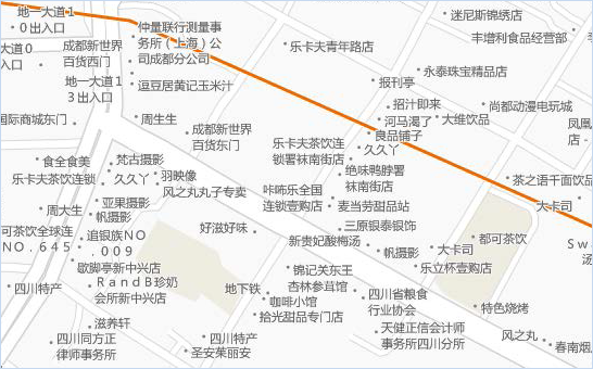
Figure: Effect after using text wrapping An effective method supported by SuperMap software for adjusting label density is setting the "cache bounds for text avoidance." This involves specifying horizontal and vertical distances, as shown below. The rectangular area defined by these values prevents other labels from overlapping it, achieving the effect of rarefied label display.
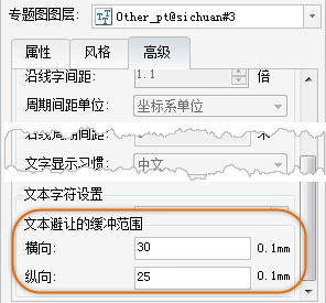
Figure: Setting cache bounds for text avoidance For the point label thematic map in the previous figure, setting "cache bounds for text avoidance" with horizontal=30 and vertical=25 (units in 0.1mm) results in the adjusted effect shown below, where label density is moderate.
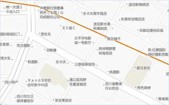
Figure: Labels after setting cache bounds for text avoidance - Controlling Frequency of Along-Line Text for Roads
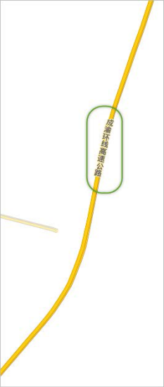
As shown below, a main road has only one label. When the map is zoomed in for browsing, this road might lack any displayed labels. How to resolve this? Below are two methods to handle such issues:
- Method 1: Enable Flow for this label thematic map layer. During browsing, labels automatically move to ensure the road always has labels displayed. The drawback is that label positions become uncontrollable, potentially affecting the map's overall aesthetic. Additionally, flow must be disabled when exporting map caches, so this method is not recommended. Instead, use Method 2 below, which employs fixed cyclic interval labeling.
- Method 2: First, disable Flow. Then, go to the Advanced tab and set the label along-line period. This allows labels to be placed at fixed cyclic intervals. Key settings for fixed cyclic interval labeling include Period Spacing Unit and Along-Line Period Spacing, which determine label frequency—i.e., the distance between labels. Period Spacing Unit has two options:
-
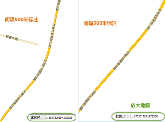
Period Spacing Unit select map unit. If the map unit is meters, the Along-Line Period Spacing value is in meters. For example, setting Along-Line Period Spacing to 500 means placing a label every 500 meters on the road. When the map scale changes, the visual spacing of labels also changes.
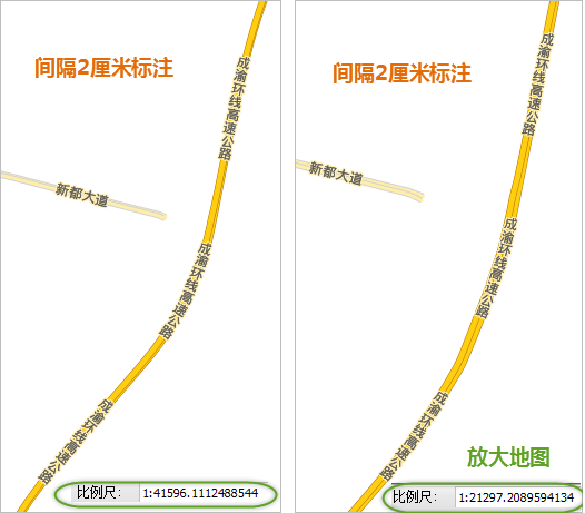
- Period Spacing Unit select the other option: 0.1mm, using screen logical units. The Along-Line Period Spacing value is then in 0.1mm. For example, setting it to 200 places a label every 2 centimeters on the screen for road line objects. When the map scale changes, label spacing consistently remains 2 centimeters on the screen.
-
Fixed cyclic interval labeling references a line object, calculating from the vectorization start point to the end point. The spacing measurement is from the end of one label to the start of the next.
When adjusting, ensure spacing is reasonable—neither too dense nor too sparse—based on design needs. As shown below, our handling of along-line label spacing uses Period Spacing Unit set to 0.1mm and Along-Line Period Spacing set to 1200 (i.e., 12 centimeters).
 |