


Two-Point Visibility
Feature Description
Determines whether two specified points have mutual visibility.
- The line-of-sight analysis function requires the presence of Grid/DEM Dataset in the current map.
- Append value: As part of the observer's total elevation, this parameter significantly affects visibility analysis results. Understanding both the surface elevation value and append value of observation points ensures more realistic analysis outcomes.
Application Example
Open the "Terrain" datasource in the "ExerciseData/RasterAnalysis" folder containing 5-meter resolution DEM data. This dataset will be used for demonstration.
Feature Entry
- Spatial Analysis Tab -> Raster Analysis -> Surface Analysis -> Two-Point Visibility;
Steps
After completion, analysis results display on both map and output window. Red lines indicate non-visible connections, green lines visible connections. The output window specifies visibility status, and when obstructed, provides coordinates of the first obstruction point with suggested elevation modifications.
- Specify observation points: Draw a line segment on the map with endpoints representing two analysis points. The drawn segment will be highlighted.
- The "2-point visibility analysis" dialog appears, displaying coordinate information for both observer and observed points. Input append values for observation points when needed.
- Click "OK" to perform the analysis.
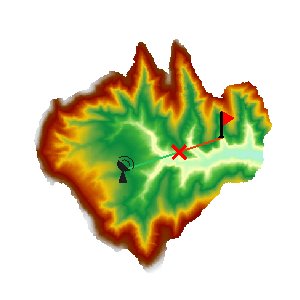 |
| Figure: Two-Point Visibility Analysis Result |
Related Topics