


Feature Description
The Solar Radiation Analysis function enables mapping and analysis of the sun's influence on a geographic area during specific time periods. It generates raster maps showing total radiation, direct solar radiation, diffuse solar radiation, and direct duration for the analysis area. This calculation considers atmospheric effects, latitude and elevation of the location, slope, aspect, daily and seasonal variations in solar angles, as well as shadows cast by surrounding terrain.
At landscape scale, topography is a key factor determining spatial variability of solar insolation. Differences in elevation, orientation (slope and aspect), and shadows cast by terrain features affect the received solar radiation. These variations also change with time of day and season, leading to microclimate differences that influence air/soil temperature, evaporation, snowmelt patterns, soil moisture, and photosynthetically active radiation.
Incident solar radiation undergoes direct transmission, scattering, and reflection through the atmosphere, then further modified by terrain and surface features before being intercepted as direct, diffuse, and reflected components at Earth's surface. Direct radiation comes from unobstructed sunlight, diffuse radiation results from atmospheric scattering by clouds and particles, while reflected radiation bounces off surfaces. The sum of these components constitutes total solar radiation.
Solar radiation analysis helps understand insolation patterns for applications in agriculture, resource management, meteorology, civil engineering, and ecological studies. Typical applications include:
- Assessing solar exposure for ski resort site selection or identifying optimal growing areas for crops requiring specific microclimates.
- Incorporating total radiation as a key factor in urban planning suitability analysis.
- Determining optimal apple cultivation areas through comprehensive analysis of direct/diffuse radiation and direct duration within specified periods.
Feature Entry
- Spatial Analysis Tab->Raster Analysis group->Solar Radiation.
- Toolbox->Raster Analysis->Solar Radiation.
Parameter Description
- Terrain Data: Select the datasource and DEM dataset for solar radiation analysis.
- Analysis Type: Supports annual radiation analysis and day radiation analysis:
- Annual Radiation Analysis: Analyzes solar radiation during specified periods within a year. Set start/end dates (month-day format) and sampling intervals:
- Start Date: Enter month-day or select from dropdown.
- End Date: If start date > end date, calculation extends to next year.
- Time Interval (Days): Default 14 days between calculations.
- Time Interval (Hours): Default 1 hour between calculations.
- Day Radiation Analysis: Analyzes radiation within a single day:
- Start Time: Default 00:00 (HH:MM format).
- End Time: Must be > start time (no cross-day analysis).
- Time Interval (Hours): Default 0.5 hours between calculations.
- Annual Radiation Analysis: Analyzes solar radiation during specified periods within a year. Set start/end dates (month-day format) and sampling intervals:
- Radiation Parameters:
- Latitude: [-90,90]. Central latitude for solar position calculations. Automatically detected for geographic/projected coordinate systems with valid locations. Mandatory for planar coordinate systems.
- Transmittance: Ratio of surface energy to extraterrestrial radiation (0-1). Typical values: 0.6-0.7 (clear sky), 0.5 (partly cloudy).
- Elevation Scaling Factor: Converts elevation units to match XY units. Default 1 (no scaling). For geographic coordinates (degrees) with elevation in meters, use recommended z-factors:
   Latitude     Z-factor
       0         0.00000898
      10         0.00000912
      20         0.00000956
      30         0.00001036
      40         0.00001171
      50         0.00001395
      60         0.00001792
      70         0.00002619
      80         0.00005156
- Result Raster:
- Datasource: Output datasource selection.
- Total Radiation: Output dataset name for total radiation.
- Direct Radiation: Check to generate direct radiation dataset.
- Diffuse Radiation: Check to generate diffuse radiation dataset.
- Direct Duration: Check to generate direct sunlight duration dataset.
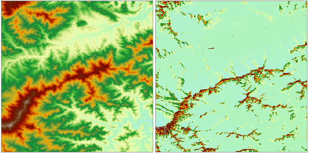
Figure: Solar Radiation Analysis Results
 Caution:
- Computation time increases significantly with DEM size - may take hours for large datasets.
- Day radiation analysis requires start time < end time within 24-hour period.
- Annual analysis allows cross-year date ranges (e.g., Oct 1 - Jan 31 next year).