


Feature Description
Simple density analysis calculates the quantity per unit area within a specified neighborhood shape around each point. The resampling method divides the point's measurement value by the specified neighborhood area. Where neighborhoods overlap, their density values are summed. Each output raster cell's density equals the sum of all overlapping neighborhood density values.
The unit of result raster values is the inverse square of the original dataset's unit. For example, if the original dataset uses meters, the result raster unit becomes per square meter.
Note: For GCS datasets, result raster values are in "per square degree" which lacks practical significance.
Open the Shop datasource in "ExerciseData/RasterAnalysis", which contains a Shop point dataset showing member distribution of a chain store. We'll use this data for demonstration.
Feature Entry
- Spatial Analysis Tab -> Raster Analysis group -> Density Analysis -> Simple Density Analysis.
- Toolbox -> Raster Analysis -> Density Analysis -> Simple Density Analysis.
Parameter Description
Displays and sets the kernel density analysis extent. Defaults to dataset bounds.
Below shows the distribution map of a chain store's membership promotion:
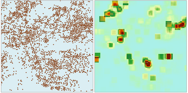 |
| Figure: Simple Density Analysis Result |
The analysis result reveals denser member distribution in darker-colored areas and sparser distribution in lighter-colored regions.
- Source Dataset
- Datasources: Select the datasource containing the dataset for analysis.
- Dataset: Choose the point dataset for analysis. The system automatically filters to show only point datasets in the selected datasource.
- Density Field: Select the numerical field for analysis. Non-numeric fields are automatically filtered out. Ensure your dataset contains appropriate fields before analysis.
- Analysis Bounds
- Result Data
- Datasource: Select the output datasource for results.
- Dataset: Enter the output dataset name. Existing names will trigger an invalid name prompt.
- Resolution: Set the result raster's resolution (ground area per cell), using the same unit as the dataset.
- Shape Settings
- Neighborhood Shape: Specifies the neighborhood shape for density calculation, with four options:
- Rectangle: Requires width and height parameters.
- Circle: Requires radius parameter.
- Annulus: Requires inner radius and outer radius parameters.
- Sector: Requires start angle (0-360°), end angle (0-360°), and radius parameters.
- Unit Type: Two options available:
- Cell Count: Uses raster cells (default: 3 cells)
- GCS: Matches dataset units (default: 1/20 of dataset bounds length)
- Neighborhood Shape: Specifies the neighborhood shape for density calculation, with four options: