


Distance raster analysis involves analyzing every cell and its neighboring cells to establish spatial relationships. It considers not only surface distance but also various cost factors. This analysis provides valuable information for resource management and planning, such as calculating emergency evacuation routes from earthquake zones to hospitals, or evaluating service areas for chain supermarkets.
Distance raster analysis primarily includes three aspects:
- Generate distance raster: Calculates the distance from each cell to the nearest source (object of interest), including Euclidean distance, cost distance, and surface distance. Also generates corresponding direction raster and allocation raster.
- Analyze shortest path from target to source using direction and allocation rasters.
- Calculate shortest path between two points (source and target), including minimum cost path and shortest surface distance path.
Basic Concepts
Key concepts in distance raster analysis:
Source: Objects of interest such as schools, roads, or fire hydrants.
Source dataset: Dataset containing sources, which can be 2D point, line, region, or raster datasets. For raster datasets, cells not representing sources should be NoData.
Distance types:
- Euclidean distance: Straight-line distance from each cell to the nearest source.
- Cost distance: Weighted cost value considering various factors for reaching the nearest source.
- Surface distance: Actual surface distance calculated using elevation data.
Euclidean distance represents the simplest cost measurement. In real-world scenarios, cost distance extends Euclidean distance by accounting for terrain obstacles like rivers and mountains.
Cost raster: Required for generating cost distance rasters and calculating minimum cost paths. Each cell value represents unit cost (non-negative) to traverse that cell. Cost units can be time, money, or unitless values like normalized slopes. Total cost equals unit cost multiplied by cell size.
3. Calculate Shortest Path Between Points
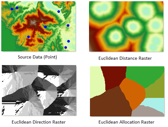
Generate Distance Raster
This function calculates three types of outputs for raster data:
- Distance from each cell to the nearest source (e.g., distance to nearest school)
- Direction to the nearest source (e.g., compass bearing to nearest school)
- Allocation of cells to nearest sources (e.g., service areas for multiple schools)
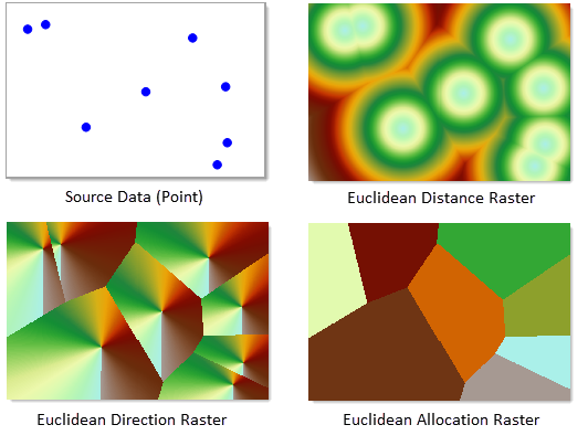
The process generates three datasets: distance raster, direction raster, and allocation raster as shown:
 |
Includes Euclidean distance raster and cost distance raster.
- Euclidean Distance Raster
Represents straight-line distance to nearest sources. Calculated using vector or raster source data. Output includes Euclidean distance raster, direction raster, and allocation raster. The distance between two points (x1,y1) and (x2,y2) is:
- Cost Distance
Represents accumulated cost to reach nearest sources, considering weighted cost factors. For example, while mountain traversal might have lower distance cost, time cost might be higher than detouring. Cost distance extends Euclidean analysis by incorporating real-world obstacles.
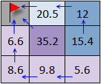
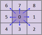
Indicates azimuth direction (0-360 degrees clockwise from north) to nearest source. Cost direction raster shows movement direction along least-cost path. Source cells have value 0. Example diagrams demonstrate cost direction values:
 |
 |
 |
| Figure 1 | Figure 2 | Figure 3 |
Assigns cells to nearest sources, useful for service area analysis (e.g., postal service zones). Contains Euclidean allocation (based on straight-line distance) and cost allocation (based on accumulated cost). Example shows allocation using DEM cost data:
 |
Compute Shortest Path
Calculates optimal paths from targets to nearest sources using pre-generated distance and direction rasters. Three path types:
- Pixel Path: Generates path for each target cell.

Figure: Pixel Path Analysis - Zonal Path: Generates path per continuous zone of equal value.
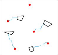
Figure: Zonal Path Analysis - Single Path: Generates single optimal path for entire target area.
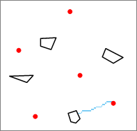
Figure: Single Path Analysis
Calculate Shortest Path Between Points
Computes optimal routes between specific source and target points considering surface distance, minimum cost, or combined factors.
Raster Cost Distance
Requires cost raster specifying unit traversal cost per cell. Cost factors may include terrain resistance, land use types, or slope gradients. Total cost equals unit cost multiplied by cell size. Multiple factors can be weighted for comprehensive analysis. Cost values must be non-negative.