


Enable Dynamic Projection
Feature Description
Dynamic projection is the process of converting one projected coordinate system when two data with different projection systems are loaded in a map (converting the later-loaded data to a coordinate system consistent with the current map's projection). This ensures the projection systems are aligned, allowing data from the same or adjacent areas to be overlaid and displayed correctly.
Function Access
- Map Properties->Coordinate System->Dynamic Projection option.
Operation Instructions
- Open the Map Properties panel and check the checkbox in front of Dynamic Projection.
- This parameter controls whether each layer in the current map is displayed with the same projection through dynamic projection. When this option is checked, dynamic projection is performed; when unchecked, dynamic projection is not performed.
- As shown in the figure below, data for a certain area is stored in two datasets with different projection types. Therefore, when adding these two datasets to a map for display, the data will be misaligned, meaning it does not match the actual situation.
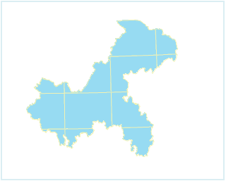
Figure: Actual extent of a certain area - If the 'Dynamic Projection' checkbox is not checked, when adding two data with different projections to the same map, a 'Coordinate System Prompts' dialog box will pop up. Click the 'Yes' button in the dialog box to automatically enable dynamic projection.
- After enabling dynamic projection, the two data are displayed with a unified projection in the map, and the display effects are as shown below.
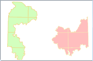
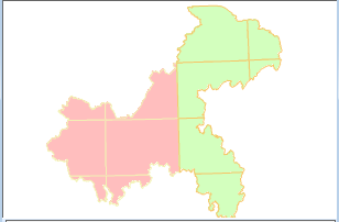
Figure: Display effects before using dynamic projection Figure: Display effects after using dynamic projection
- When enabling dynamic projection, it supports setting transformation parameters for the projection. Users can click the 'Transformation Parameters' button, and in the popped-up 'Parameter Settings' dialog box, set the projection transformation parameters. For detailed descriptions of parameter settings, please refer to Dataset Projection Conversion.
 Note:
Note:Web maps (including OGC, SuperMap Cloud Services, Google Maps, etc.) do not currently support dynamic projection.
Related Topics