


Line to Region
function description
Convert the selected line object to a region object, and save to a region dataset or CAD dataset.
When converting line objects to region objects, closed line objects are transformed into the boundaries of region objects; unclosed line objects will be connected end-to-end and then transformed into the boundaries of region objects. As shown in the following figures, Figure 1 converts closed line objects to region objects, and Figure 2 converts unclosed line objects to region objects.
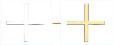 |
| Figure 1: Converting Closed Line Objects |
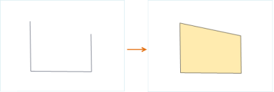 |
| Figure 2: Converting Unclosed Line Objects |
Function Entry
- Edit Data Tab -> Feature Editing Group -> Type Conversion > Line to Region
Operation Instructions
- Open the line dataset into the map, and under the condition that the current line layer is selectable, select one or more line objects.
- In the Edit Data tab's Type Conversion drop-down menu, click the Line to Region button to pop up the Line to Region dialog.
- In the dialog, select the target datasource and dataset for storing the newly generated region objects. There are two ways to save the result data: save to an existing dataset or create a new region dataset to save. The parameters in the dialog are as follows:
- Target Datasource: Sets the datasource where the result dataset is to be saved.
- Target Dataset: Select an existing region or CAD dataset to store the newly generated region objects.
- New Dataset: Check the New Dataset checkbox, set the name of the new dataset, and save the newly generated region objects to the newly created region dataset.
- Delete Source Object: If the selected line object layer is editable, you can check the Delete Source Object checkbox to delete the selected objects in the source dataset.
- Click the OK button to complete the conversion of line objects to region features.
 Notes:
- One line object generates one region object, and combined line objects generate combined region objects.
- Straight lines cannot be converted to region objects. If there are straight lines among the selected line objects, the output window will prompt that the straight line objects failed to convert.