


Polygon Split
Function Description
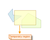
Splits lines or regions by drawing a temporary split polygon.
The Polygon Split button is only available when there is an editable layer in the current Map and one or more selected objects exist in the layer.
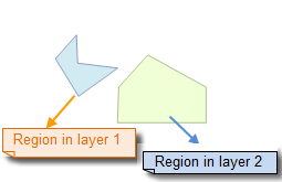
When multi-layer editing is enabled, the drawn temporary split polygon will split all selected lines or regions in the editable layers it traverses, and these objects can be on different layers.
Function Entry
- Edit Data Tab -> Feature Editing Group -> General editing -> Partition -> Polygon Split
Operation Instructions
- Set the object layer of lines or polygon geometries to be split in the Map to editable state.
- Click to select the line or region to be split. Or, select multiple geometries by dragging a box or holding the Shift key.
- In the Edit Data tab, under the General editing drop-down menu, click the Polygon Split button in the Partition group to perform the polygon split operation. At this point, the operation status in the current Map is set to polygon split for lines or regions.
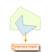
- Draw the temporary split polygon, i.e., draw a temporary polygon for splitting lines or regions. The specific operation is: move the mouse to the Map to draw the split polygon, click the left mouse button at an appropriate position to determine the first point of the split polygon, move the mouse, and a temporary line segment that changes with mouse movement will appear. Click the mouse at an appropriate position to determine the next point of the split polygon, and continue clicking to draw other points of the temporary split polygon.
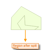
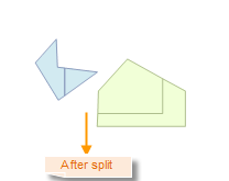
- After the temporary split polygon is drawn, right-click the mouse to end the drawing. At this point, the split operation will be executed, and the temporary split polygon will disappear.
- The result of the split is: all selected lines or regions in the editable layers traversed by the temporary split polygon will be split into separate objects at the intersections with the split polygon.
- To continue with the next polygon split operation, repeat step 4 above. If you want to add lines or regions from other data for splitting, then add data and set the corresponding layer to editable state, and then repeat step 4 above.
- To cancel the polygon split operation status, simply click the Polygon Split button to make it not pressed.
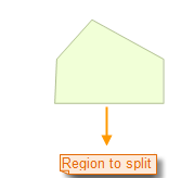
Polygon Split Operation Illustration:
 |
 |
 |
Cross-Layer Splitting
 |
 |
 |
 Notes:
- When multi-layer editing is enabled, users can simultaneously polygon split lines or regions in multiple editable layers.
- Parametric objects do not support polygon split, such as circles, arcs, ellipses, etc.