


Browse Outline Attribute Table
Select the mosaic dataset from the datasource list, right-click Browse Footprint Attributes, and open the attribute table of the mosaic dataset, which essentially serves as the attribute table for the footprints. Each record corresponds to a footprint object. The main fields in the attribute table are as follows:
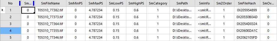 |
| Figure: Attribute Table |
- SmFileName: The file name (excluding extension) of all original images managed within the mosaic dataset, as well as the overview file name (including extension).
- SmPath: The full path (absolute path) of all original image files managed in the mosaic dataset, along with the full path of overview files. These paths support network shared paths, allowing the mosaic dataset to be shared by editing this field.
- SmCategory: Identifies whether the currently displayed image within the footprint is an original image file or an overview. A value of 1 indicates an original image file, while 2 represents an overview.
- SmMinPS and SmMaxPS: These values are derived from LowPS/HighPS calculations. They control which resolution of raster data is used to generate dynamic mosaicked images during display. Typically, when there is no overview, SmMinPS is 0, and SmMaxPS is HighPS × 10.
- Example: For the multispectral band of GF-1 satellite, if SmLowPS = 8 meters and SmHighPS = 16 meters, then SmMinPS = 0 and SmMaxPS = 160.
- The units of SmMinPS/SmMaxPS depend on the map coordinate system:
- In a geographic coordinate system, the unit is degrees.
- In a projected coordinate system, the unit is meters.
- SmLowPS and SmHighPS: Extracted from raster data, these define the minimum and maximum resolution of the raster data. The units vary based on the mosaic dataset's coordinate system:
- In a geographic coordinate system, the unit is degrees.
- In a projected coordinate system, the unit is meters.
- Example:
- For GF-1 satellite data, the multispectral band resolution is 8 meters, and the panchromatic band resolution is 2 meters.
- Without pyramids, SmLowPS/SmHighPS values remain equal in the attribute table.
- After creating pyramids:
- LowPS represents the base resolution.
- HighPS indicates the resolution of the top-level pyramid pixels.
- Example:
- Multispectral band: base resolution = 8 meters, top-level pyramid resolution = 16 meters.
- Panchromatic band: base resolution = 2 meters, top-level pyramid resolution = 16 meters.
- SmZOrder: Default value is 1. Users can modify this field to control the display order of images. By default, images are displayed in descending SmID order. For more details, refer to Display Order Settings.
Related Topics