


Feature Description
Calculates the geometric properties of zones with the same cell value in the raster data and outputs them to a result table. These properties include the source raster value, zone area, zone perimeter, thickness, centroid X coordinate, centroid Y coordinate, major semi-axis length, minor semi-axis length, and ellipse orientation.
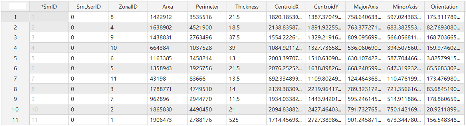
Result field descriptions:
ZonalID: Zone ID, which is the field storing the source raster value (long type). All other property fields are of double type.
Area: The area of the zone. Based on cells with the same value forming a zone, the area is calculated as the product of the number of cells within the zone and the pixel size.
Perimeter: The perimeter of the zone. Calculated by summing the lengths of the cells that constitute the boundary of each zone.
Thickness: The thickness. Calculates the distance from the outermost cell to the deepest or thickest point within each zone.
CentroidX: The X coordinate of the centroid point. By calculating the eigenvalues and eigenvectors of each zone's shape, an ellipse is created to approximate the zone's geometry. The center of this ellipse is used as the zone's centroid.
CentroidY: The Y coordinate of the centroid point. By calculating the eigenvalues and eigenvectors of each zone's shape, an ellipse is created to approximate the zone's geometry. The center of this ellipse is used as the zone's centroid.
MajorAxis: The length of the ellipse's major axis.
MinorAxis: The length of the ellipse's minor axis.
Orientation: The orientation angle of the ellipse. The angle between the X-axis and the major axis of the ellipse, with due east as 0 degrees and counterclockwise as the positive direction. The value ranges from 0 to 180. If the ellipse for a specific zone is calculated as a circle (major and minor axes equal), its orientation is set to 90 degrees.
Unit descriptions:
- The unit for the ellipse orientation angle is degrees.
- The units for all other property values are consistent with the units of the source raster data.
Parameter description
| Parameter Name | Parameter Interpretation | Parameter Type |
|---|---|---|
| Grid Area Dataset | Supports only raster datasets with an integer pixel format. Cells with the same value constitute a zone. Each zone does not need to be a contiguous area; it can consist of many scattered parts. NoData areas are treated as blank and are excluded from calculation. | Dataset |
| Target Datasource | The specified datasource for storing the result data. | Datasource |
| The Name of the Resulting Dataset | The specified name for the resulting dataset. | String |
Output Result
| Parameter Name | Parameter Interpretation | Parameter Type |
|---|---|---|
| Attribute Table | The result table. Property fields include source raster value, zone area, zone perimeter, thickness, centroid X coordinate, centroid Y coordinate, major semi-axis length, minor semi-axis length, and ellipse orientation. | DatasetVector |