


Feature Description
Rivers within a watershed are classified as main streams and tributaries. In hydrology, rivers are graded based on factors such as flow rate and morphology. In hydrology, certain characteristics of a river can be inferred from its stream order.
The River Classification function is used to grade rivers. Based on the raster river system data, it assigns stream order numbers according to the direction raster. A higher number indicates a higher order. Currently, SuperMap provides two river classification methods: the Strahler method and the Shreve method.
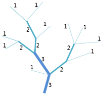
Strahler River Classification Method
The Strahler river classification method was proposed by Strahler in 1957. Its rules are defined as follows: Rivers originating directly from a source are first-order streams; The stream order formed by the confluence of two rivers of the same order increases by one; The stream order formed by the confluence of two rivers of different orders equals the higher order of the two original rivers.The Strahler method is the most common stream ordering method. However, because this method only increases the order when rivers of the same order meet, it only preserves the order of the highest-order connecting line and does not consider all connecting lines in the drainage network.
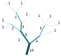
Shreve River Classification Method
The Shreve river classification method was proposed by Shreve in 1966. Its rules are defined as follows: Rivers originating directly from a source are assigned an order of 1; The stream order formed by the confluence of two rivers is the sum of their orders. For example, two first-order rivers merging form a second-order river, while a second-order river and a third-order river merging form a fifth-order river.The Shreve method considers all connecting lines in the drainage network. The magnitude of a connecting line essentially represents the number of upstream connecting lines.
Parameter Description
| Parameter Name | Default Value | Parameter Interpretation | Parameter Type |
|---|---|---|---|
| River System Raster Data | Select the data source and dataset containing the raster river system data. | DatasetGrid | |
| Direction Raster Data | Select the data source and dataset containing the flow direction data. Generated by the Calculate Flow Direction tool. | DatasetGrid | |
| River Classification Method | STRAHLER | The river classification method, which can be the STRAHLER method or the SHREVE method. | StreamOrderType |
| Target Datasource | The specified data source where the resulting dataset will be stored. | Datasource | |
| The Name of the Resulting Dataset | The specified name for the resulting dataset. | String |
Output Result
| Parameter Name | Parameter Interpretation | Parameter Type |
|---|---|---|
| River Grading Grid | The river grading grid. | DatasetGrid |