


Extract Longest Flow Path
Feature Description
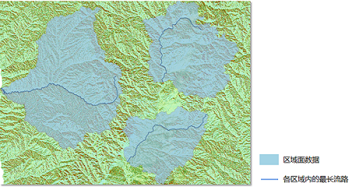
This function traces the longest flow path by inputting an eight-direction flow direction raster dataset and an area surface dataset, obtaining the longest river path within each region.
Parameter description
| Parameter Name | Default Value | parameter interpretation | parameter type |
|---|---|---|---|
| flow direction data | Select the datasource and dataset containing the flow direction raster | DatasetGrid | |
| Area Surface Data | The specified area surface dataset. | DatasetVector | |
| Area ID field | The area surface ID field name, which is the unique identifier for the area surface. It can be set to SmID. | String | |
| target datasource | The datasource where the result dataset will be stored | Datasource | |
| the name of the resulting dataset | The specified name for the resulting dataset | String |
Output Result
| Parameter Name | parameter interpretation | parameter type |
|---|---|---|
| Result River Line Dataset | Result river line dataset | DatasetVector |
- A "CatchmentID" field will be created in the line dataset, establishing a one-to-one correspondence between the river line and the area surface object.