


Feature Description
Flow length refers to the distance (or weighted distance) from each cell along the flow direction to its starting or ending point, including both upstream and downstream directions. This measurement directly affects surface runoff velocity and consequently influences soil erosion dynamics. It serves as a crucial evaluation factor for soil erosion and water conservation.
Notes:
Flow direction data is mandatory for flow length calculation.
Direction specification is required:
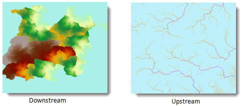
Downstream: Calculates the longest distance from each cell to the watershed outlet.
Upstream: Calculates the longest distance from each cell to the upstream drainage divide.The following illustration shows flow length rasters calculated in both directions:
For weighted distance calculation, a weight raster must be provided.
The weight raster defines flow resistance between cells. The resulting flow length becomes weighted distance when applying weights. For example, in flood modeling where factors like slope, soil saturation, and vegetation coverage impede flood flow, these factors should be modeled through weight datasets.
Parameter Description
| Parameter | Default | Description | Type |
|---|---|---|---|
| Flow Direction Data | Select the datasource and dataset of flow direction raster | DatasetGrid | |
| Weight Raster (Optional) |
Select the datasource and dataset of weight raster. Used for weighted flow length calculation. | DatasetGrid | |
| Flow Direction Type | false | Specifies flow length calculation direction: | |
true for upstream, false for downstream (default). See feature description for details. |
Boolean | ||
| Target Datasource | Specifies the datasource to store results | Datasource | |
| Result Dataset | Specifies the name of result dataset | String |
Output
| Parameter | Description | Type |
|---|---|---|
| Result Flow Length | Result flow length map | DatasetGrid |