


Calculate the Water Catchment
Feature Description
Calculate the Water Catchment is used to compute the water accumulation for each cell based on the direction raster. Optionally, weight data can be used to calculate weighted water accumulation.
The idea behind Calculate the Water Catchment is as follows:
Assume that each cell in the raster data has a unit amount of water. Based on the flow direction map, compute the accumulated water amount for each cell (excluding the water amount of the current cell). The following figure shows the process of Calculate the Water Catchment using flow direction.
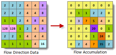
- The computed result represents the total accumulated water catchment for each cell. This value is the sum of the water accumulation from all upstream cells flowing into the current cell, excluding the water catchment of the current cell being processed.
- In practical applications, the water amount for each cell may not be the same. It is necessary to specify weight data to obtain the actual water catchment. When weight data is used, in the calculation of water catchment, the water amount for each cell is no longer a unit but multiplied by the weight (the raster value of the weight dataset). For example, if the average rainfall during a certain period is used as weight data, the computed water catchment represents the rainfall flowing through each cell during that period.
- The resulting values of the computed water catchment can help us identify valleys and watersheds. A cell with high water catchment indicates that the point is at a lower elevation and can be considered a valley; a cell with zero water catchment indicates that the point is at a higher elevation and may be a watershed. Therefore, water catchment provides a reference for extracting various characteristic parameters of watersheds, such as watershed area, perimeter, drainage density, etc.
Parameter description
| Parameter Name | Default Value | Parameter Interpretation | Parameter Type |
|---|---|---|---|
| Flow Direction Data | Select the datasource and dataset where the direction raster is located. | DatasetGrid | |
| Weight Raster Data (Optional) |
Select the datasource and dataset where the weight raster is located. During Calculate the Water Catchment, the weight raster is used to weight each flow direction data. | DatasetGrid | |
| Target Datasource | The specified datasource where the resulting dataset is stored. | Datasource | |
| The Name of the Resulting Dataset | The specified resulting dataset name. | String |
Output Result
| Parameter Name | Parameter Interpretation | Parameter Type |
|---|---|---|
| Catchment Grid | Catchment Grid | DatasetGrid |