


Modeling Along Path
Usage Instructions
This tool enables rapid generation of linear models such as pipe galleries and road barriers based on a modeling path and model objects. The result data is stored in the form of model instance data.
Parameter Descriptions
| Parameter Name | Parameter Description | Parameter Type |
|---|---|---|
| Model Object (Optional) |
Input model object, which can be specified by the output of tools such as Import Model and Create LOD. | Model |
| Model File (Optional) |
Select a model file. Supported model file formats include: *.s3mb, *.3ds, *.dae, *.osgb, *.off, *.fbx, *.gltf, *.stl, *.obj. | String |
| Transformation Matrix (Optional) |
Specify a transformation matrix to translate, rotate, and scale the model object to achieve the desired spatial position. It can be specified by the output of the Transformation Matrix tool. | Matrix |
| Modeling Path | Specify the lofting path for the model object, which must be a 3D line object. The model will be lofted along the path in its own Y-axis direction. This parameter can be specified by the output result of tools such as Get Dataset Geometry Collection. | Geometry |
| Model Smoothing Coefficient (Optional) |
Set the smoothness at turns of the model. The larger the smoothing coefficient, the smoother the turns, but the computation time and result data volume will increase. | Integer |
| Modeling Spacing (Optional) |
Set the distance between each model object along the modeling path, in meters. When the interval distance is greater than 0, the model objects will be distributed along the lofting path at the specified distance. | Double |
| Path Simplification Threshold (Optional) |
Set the threshold for simplifying the modeling path. The larger the value, the higher the degree of simplification. Unit: meter, default value: 0.1. When this parameter equals 0, the system will not simplify the modeling path; when it is greater than 0, the system will simplify the modeling path according to the threshold, i.e., remove points whose vertical distance to the line connecting their start and end points is less than the threshold (as shown in the figure below); when it is less than 0, the system will perform adaptive simplification on the modeling path.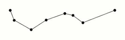 |
Double |
| Flip (Optional) |
Set whether to flip the model object. | Boolean |
| Is Longitude/Latitude (Optional) |
Set whether the coordinates of the geometry object representing the modeling path are longitude and latitude. | Boolean |
Output Results
| Parameter Name | Parameter Description | Parameter Type |
|---|---|---|
| Modeling Result | Result model instance data | InstanceCollection |