GeoSOT 3D Encoding
Feature Description
Performs 3D grid encoding based on GeoSOT for the dataset, which involves spatial partitioning of geospace along longitude, latitude, and geodetic height dimensions according to GeoSOT standards. Each 3D grid unit is assigned corresponding quaternary 2D grid codes and height domain codes. Detailed partitioning and encoding methods refer to 《Geospatial Grid Coding Rules GB/T 40087-2021》.
Parameter Description
| Parameter | Default Value | Description | Type |
|---|---|---|---|
| Source Dataset | The vector dataset to be encoded. Supports 3D point/line/region and model datasets. Only datasets with geographic coordinate systems are supported. | DatasetVector | |
| 2D Location Code Field Name (Optional) |
GeoSOT_2D_Code | Specifies the field name for storing quaternary 2D grid location codes. Must be a new field not existing in the original data. | String |
| Height Location Code Field Name (Optional) |
GeoSOT_H_Code | Specifies the field name for storing binary height domain codes. Must be a new field not existing in the original data. | String |
Output
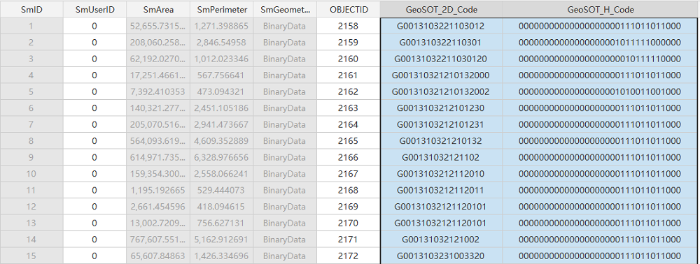
If successful, two new fields "GeoSOT_2D_Code" and "GeoSOT_H_Code" will be added to the source dataset, storing quaternary 2D grid location codes and binary height domain codes respectively.
- GeoSOT quaternary 2D grid codes start with "G", followed by digits indicating the minimum partitioning level (up to level 32) that fully encloses geometric objects.
- Height domain codes start with "0" for above ground level and "1" below ground level, with digits representing the minimum partitioning level (up to level 32).
Examples:
2D spatial code: G00131331010 indicates the minimum partitioning level is 11.
Height domain code: 00011111111111111 indicates the height partitioning level is 17.


