


Feature Description
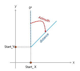
The bearing distance to line function automatically calculates and generates corresponding spatial line data based on known starting point coordinates, bearing, and distance.
This function can be used for visualization analysis of field verification and surveying results. Based on photos taken during field verification with bearing and estimated distance information, it can automatically construct "line of sight" segments, intuitively reproducing the shooting direction and field of view, providing intuitive spatial orientation and distance references for accurately locating features in photos during indoor work.
Functional Principle
This function automatically calculates the endpoint position and generates a line segment based on the input coordinates, bearing, and distance parameters. It provides two core calculation methods following different spatial geometric models to adapt to different data coordinate systems and accuracy requirements.
- Geodesic mode, suitable for geographic coordinate systems, treats the Earth as an ellipsoid and calculates the shortest path (great circle route) between two points on the Earth's surface, with bearing based on true north. The output geodesic is densified into a polyline when stored to approximate the true curve; short segments may approximate straight lines, while long segments require more vertices to represent their path.
- Plane line mode, available only when the target coordinate system is a projected coordinate system, uses planar trigonometric formulas directly in the projection plane, with bearing based on grid north, suitable for small-scale areas where the Earth's curvature can be ignored.
Supported starting from SuperMap iDesktopX 2026 version.
Parameter Description
| Parameter Name | Parameter Interpretation | Parameter Type |
|---|---|---|
| Dataset | Specifies the source dataset containing starting point coordinates, distance, bearing, and other information. | DatasetVector |
| X Field | Specifies the field that records the starting point X coordinate (or longitude). | String |
| Y Field | Specifies the field that records the starting point Y coordinate (or latitude). | String |
| Distance Field | Specifies the field that records the length of the line segment. | String |
| Distance Unit |
Specifies the unit of the 'Distance Field' values. Supportsm, km, mi, nautical miles, feet, default is meters. |
Unit |
| Bearing Field | Specifies the field that records the bearing value. Angles are measured clockwise from north. |
String |
| Line Type |
Specifies the line type for the generated result.
|
String |
| ID |
Specifies a field used as a unique identifier for input records; its value will be retained in the output result, facilitating subsequent connection of more attributes. |
String |
| Target Coordinate System | Sets the coordinate system for the output result, default value is GCS_WGS_1984. | PrjCoordSys |
| Retain Attributes |
Specifies whether to add other input fields to the output result.
|
Boolean |
Output Result
| Parameter Name | Parameter Interpretation | Parameter Type |
|---|---|---|
| Result Dataset | The result is a line dataset, with the default dataset name as "resultDataName" | DatasetVector |