Feature Description
The rapid development of modern information technology is accelerating human society into the big data era. With the widespread adoption of global satellite navigation systems (GNSS) such as BeiDou, position information plays an increasingly important role in various big data applications in economic construction, social development, and people's daily lives.
The BeiDou grid location code is developed based on the earth space subdivision theory, suitable for various application terminals of the BeiDou satellite navigation system to output a grid location code. It shares the same origin and lineage with the encoding system based on the GeoSOT model, designed to match the positioning accuracy of the BeiDou satellite navigation system, while considering both human and device usage, it's an important supplement to the latitude and longitude point location encoding system.
Combined with the BeiDou system and BeiDou enhancement system, the BeiDou grid code will provide users with a new spatial location services model, greatly improving the efficiency of big data organization, management, computation, analysis, query, and integration. The widespread application of the BeiDou grid code can not only bring significant benefits to applications in various industries such as high-precision location services, the Internet of Things, and smart cities, but also has great importance for national informatization construction, modernization of governance capabilities, and the establishment of the national big data system.
This method generates the corresponding BeiDou two-dimensional grid location code for each geometry in the dataset. For detailed subdivision and encoding methods, refer to 'BeiDou Grid Location Code_GB_T 39409-2020'.
Parameter Description
| Parameter Name | Default Value | Parameter Interpretation | Parameter Type |
|---|---|---|---|
| Source Dataset | The vector dataset to be encoded, supporting point, line, polygon, three-dimensional point, line, polygon, and model dataset types. Only datasets in the latitude and longitude coordinate system are supported. | DatasetVector | |
| Two-Dimensional Position Code Word Segment Name (Optional) |
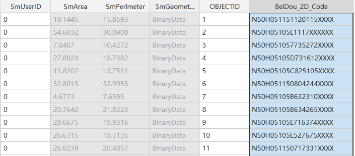
BeiDou_2D_Code | The specified field name for storing the two-dimensional grid location code, which must not exist in the source data. | String |
Output Result
If executed successfully, a new field "BeiDou_2D_Code" is added to the source dataset, used to store the 20-digit BeiDou two-dimensional location code.