


Feature Description
Polygon aggregation merges polygon features within a specified distance into a new polygon feature, resulting in an aggregated polygon dataset.
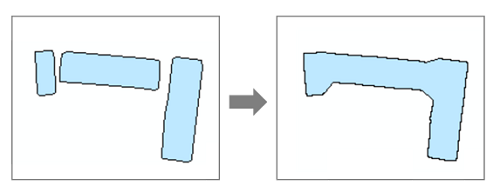
A common application scenario is determining the aggregation degree of rural residential areas, which often requires indicators like contiguity. Contiguity refers to aggregating plots or houses within a certain range into a single patch. For example, with an aggregation bound distance of 100 meters for construction land plots, a 100-meter buffer is applied to each plot to be aggregated, merging all plots within that range.
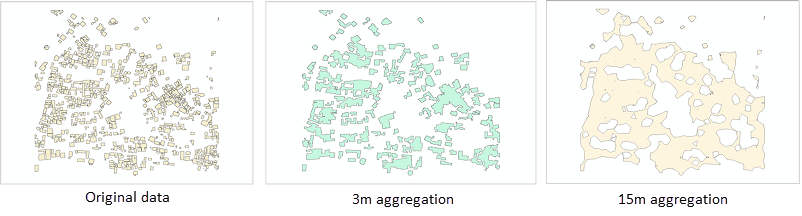
Different aggregation bound distances produce different effects, as shown below:
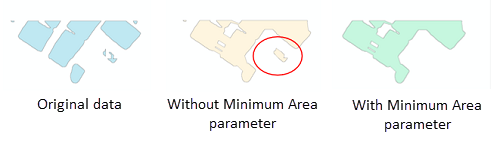
Sometimes, independent sliver polygons may appear in the result. These can be eliminated by setting the limited area parameter, as shown below:
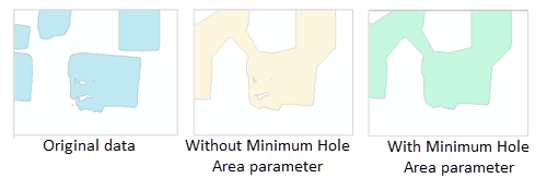
Sometimes, holes (voids) may appear in the result. These can be eliminated by setting the holes define an area parameter, as shown below:
Parameter description
| Parameter Name | Default Value | Parameter Interpretation | Parameter Type |
|---|---|---|---|
| source dataset | Source dataset | DatasetVector | |
| target datasource | Specifies the datasource that stores the analysis results dataset. | Datasource | |
| the name of the resulting dataset | Specifies the resulting dataset name. | String | |
| aggregation bound distance (Optional) |
0.0 | The distance that must be satisfied between the boundaries of polygon features for aggregation to occur. Aggregation will only happen where the boundaries of two polygon features are within the specified aggregation distance. The value must be greater than 0. | Double |
| Unit (Optional) |
Meter | Sets the unit for the aggregation bound distance. | Unit |
| limited area (Optional) |
0.0 | Sets the minimum area for independent sliver polygons in the aggregation result. Sliver polygons smaller than this area will be eliminated. The unit of area is consistent with the unit of the aggregation bound distance. For example, if the unit above is selected as Meter, the unit of area here is SquareMeter. The default value is 0, meaning all polygons are retained. | Double |
| holes define an area (Optional) |
0.0 | Sets the minimum area for holes inside the aggregated result polygons. Holes smaller than this area will be filled. The unit of area is consistent with the unit of the aggregation bound distance. For example, if the unit above is selected as Meter, the unit of area here is SquareMeter. The default value is 0, meaning all holes in the polygon features are retained. | Double |
| aggregation field (Optional) |
Only features with the same aggregation field value will be aggregated. Supported field value types are: Boolean, Integer, Long, Date, Timestamp. | String |
Output Result
| Parameter Name | Parameter Interpretation | Parameter Type |
|---|---|---|
| result dataset | Result dataset | DatasetVector |