



Feature Description
Redefine the value of each cell in the raster dataset. Raster reclassifying only applies to raster datasets (GRID), not to image datasets (IMAGE).
It reclassifies the cell values of the source raster data and assigns values according to the new classification criteria. The result is replacing the original cell values of the raster data with new values. For known raster data, reclassification is sometimes necessary to better visualize trends, identify patterns in cell values, or facilitate further analysis. Raster reclassifying generally includes the following four forms:
- Replace old cell values with new values. For example, when land use changes, assign a new cell value to wasteland that has been reclaimed as cultivated land.
- Reclassify and group a large number of cell values, assigning the same value to cells in the same group to simplify data. For example, classify dry land, irrigated land, and cropland all as agricultural land.
- Grade multiple raster data according to a unified standard. For example, if influencing factors for a building site selection include soil and slope, for the input data: soil type and slope raster data, they can be reclassified according to a 1-10 grade standard to facilitate further site selection analysis.
- Set certain cells that are not desired to participate in analysis as NoData, or assign new measured values to cells that were originally NoData, facilitating further analysis and processing.
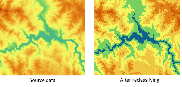
Note: When using this tool, if performing a reclassify range and the segmentation method is equal interval or natural interval, it is recommended to connect the [Build Re-grading Interval] tool in series beforehand, to conveniently fill in the range interval parameter.
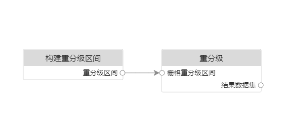
Parameter description
| Parameter Name | Default Value | Parameter Interpretation | Parameter Type |
|---|---|---|---|
| Source Raster Data | Source raster data | DatasetGrid | |
| Raster Regrading Interval | Primarily used for settings related to re-grading interval information, including the start value, end value, etc. of the interval. This parameter can be conveniently filled by connecting the [Build Re-grading Interval] tool in series beforehand. | ReclassSegment | |
| Type Of Regrading | Reclassify Range | Type of regrading. Includes Reclassify Unique Value and Reclassify Range. | ReclassType |
| Keep The Original Unclassified Unit | False | Sets whether data in the source raster data that is not within the specified interval or is not a specified single value retains its original value. | Boolean |
| Modify The Original Unclassified Unit To | 0.0 | Unclassified units are cell values not covered in the reclassification list on the left side of the dialog box. You can choose to uniformly set a new cell value for them. Takes effect when "Keep The Original Unclassified Unit" is false. | Double |
| Keep The Original Cell With No Value | False | Whether to keep the NoData values in the source raster data as NoData. | Boolean |
| Modify The Cell With No Value To | 0.0 | For NoData values in the source raster data, you can choose to keep them as NoData or set a new cell value for them. Takes effect when "Keep The Original Cell With No Value" is false. | Double |
| Result Grid Pixel Format | 16-bit | Result grid pixel format. Provides six pixel formats: 8-bit (unsigned), 16-bit (unsigned), 32-bit (integer), 64-bit (long integer), Single, and Double. | ReclassPixelFormat |
| Target Datasource | The specified datasource where the dataset storing the reclass result is located. | Datasource | |
| The Name Of The Resulting Dataset | The specified resulting dataset name. | String |
Output Result
| Parameter Name | Parameter Interpretation | Parameter Type |
|---|---|---|
| Result Dataset | Result dataset | DatasetGrid |